History in Structure

Former Coach-House & Stable Range to Hay Castle

A Grade II Listed Building in Hay-on-Wye, Powys

More Photos »
Approximate Location Map
Large Map »

Coordinates

Latitude: 52.0738 / 52°4'25"N

Longitude: -3.1263 / 3°7'34"W

OS Eastings: 322902

OS Northings: 242314

OS Grid: SO229423

Mapcode National: GBR F1.CF51

Mapcode Global: VH6BJ.R4MK

Plus Code: 9C4R3VFF+GF

Entry Name: Former Coach-House & Stable Range to Hay Castle

Listing Date: 24 October 1951

Last Amended: 1 February 1988

Grade: II

Source: Cadw

Source ID: 7406

Building Class: Domestic

ID on this website: 300007406

Location: Attached to the SW end of the Castle House and splayed forward with the yard to rear; screened from the garden by a rubble wall, partly broken down.

County: Powys

Community: Hay (Y Gelli Gandryll)

Community: Hay

Built-Up Area: Hay-on-Wye

Traditional County: Brecknockshire

Tagged with: Stable

Find accommodation in
Hay-on-Wye

Exterior

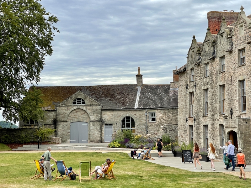
Probably C17 to N, contemporary with the house; rubble chimney stack heightened in brick. Earlier C19 single storey and attic rubble coach house with small rubble chimney stack to S of splayed joint; modern roof. Coach house has advanced and pedimented frontspiece with thermal attic window over tall blocked arched entrance and inserted small window and segmental relieving arch. Bullseye window on left gable end.

W side has swept roof loft doors and corresponding coach entrance. Large small-pane window and modern porch to the earlier range. Cobbled courtyard. Later converted into kitchens and servants hall.

Reasons for Listing

Group value with Hay Castle.

External Links

External links are from the relevant listing authority and, where applicable, Wikidata. Wikidata IDs may be related buildings as well as this specific building. If you want to add or update a link, you will need to do so by editing the Wikidata entry.

Recommended Books

Other nearby listed buildings

  • II Outbuilding Range to SW of Hay Castle
    Immediately to SW of the Castle House attached by a lintel to a former doorway across the angle. Entered from the service courtyard opposite the former coach house and stable range.
  • II Section of the Boundry Wall to Hay Castle
    Adjoining No 30 at SW end and continuing to the corner with the Market Place; set in the slope.
  • I Hay Castle
    Dominating the town with Back Fold, Castle Lane and Oxford Road bordering the castle grounds.
  • II J.Geoffrey Aspin
    Set into a continuous row of street frontages stepped up from adjoining properties.
  • II Fine Fare
    Set back on the corner with Back Fold; No 27 adjoins forward to left. Formerly the Mason's Arms PH.
  • II Hay & Cusop War Memorial
    At junction of Castle Lane and Castle Street, set into the wall of the castle grounds.
  • II River Wye Booksellers
    Set in the slope opposite Hay Castle; set forward from No 1 Castle Street to left. No 13 was formerly a bakery.
  • II H.R.Grant including former Flannel mill to rear
    Set into a row of street frontages, stepped up from the adjoining properties. The mill extends at an angle to rear set in the slope and end on to Belmont road.

BritishListedBuildings.co.uk is an independent online resource and is not associated with any government department. All government data published here is used under licence. Please do not contact BritishListedBuildings.co.uk for any queries related to any individual listed building, planning permission related to listed buildings or the listing process itself.

British Listed Buildings is a Good Stuff website.