History in Structure

J.Geoffrey Aspin

A Grade II Listed Building in Hay-on-Wye, Powys

More Photos »
Approximate Location Map
Large Map »

Coordinates

Latitude: 52.0739 / 52°4'25"N

Longitude: -3.1268 / 3°7'36"W

OS Eastings: 322869

OS Northings: 242321

OS Grid: SO228423

Mapcode National: GBR F1.CF1R

Mapcode Global: VH6BJ.R4CH

Plus Code: 9C4R3VFF+G7

Entry Name: J.Geoffrey Aspin

Listing Date: 1 February 1988

Last Amended: 1 February 1988

Grade: II

Source: Cadw

Source ID: 7340

Building Class: Commercial

ID on this website: 300007340

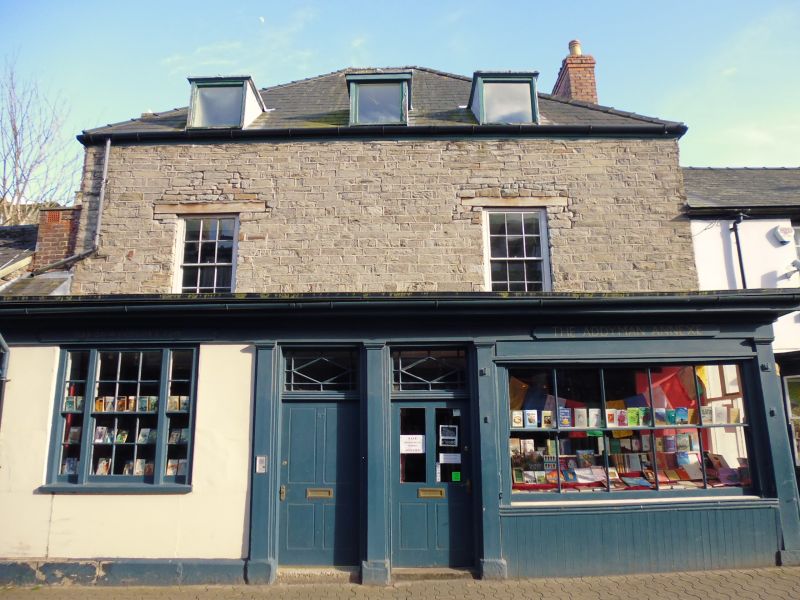
Location: Set into a continuous row of street frontages stepped up from adjoining properties.

County: Powys

Community: Hay (Y Gelli Gandryll)

Community: Hay

Built-Up Area: Hay-on-Wye

Traditional County: Brecknockshire

Tagged with: Building

Find accommodation in
Hay-on-Wye

Exterior

Probably C17, substantially altered. 2-storey and attic 3-bay high coursed rubble front with advanced flat roof shop front. Tall hipped slate roof with end brick chimney stacks and further brick stack to front left hand corner over slate roofed cross passage. Flat roofed modern dormers with casement windows and 2 widely spaced small pane sash windows to 1st floor. Tripartite small pane sash to left hand side of shop front and broad horned sash to right; wide cornice, pilaster strips to ends and flanking paired central entrances with fanlights and scribed panelled doors, half-glazed to right. Similar door to cross passage.

Rubble chimney breast to left end; modernised rear with cross range to left extending to edge of Castle grounds.

Interior

Modernised interior.

Reasons for Listing

Group value with neighbouring listed items in Castle Street.

External Links

External links are from the relevant listing authority and, where applicable, Wikidata. Wikidata IDs may be related buildings as well as this specific building. If you want to add or update a link, you will need to do so by editing the Wikidata entry.

Recommended Books

Other nearby listed buildings

  • II Fine Fare
    Set back on the corner with Back Fold; No 27 adjoins forward to left. Formerly the Mason's Arms PH.
  • II H.R.Grant including former Flannel mill to rear
    Set into a row of street frontages, stepped up from the adjoining properties. The mill extends at an angle to rear set in the slope and end on to Belmont road.
  • II Outbuilding Range to SW of Hay Castle
    Immediately to SW of the Castle House attached by a lintel to a former doorway across the angle. Entered from the service courtyard opposite the former coach house and stable range.
  • II Steve Davies Domestic Appliances
    Part of a small group towards the corner with Belmont Road, stepped down from No 6. No 8 was formerly the Dog Inn and later the Talbot Inn.
  • II Hay Cottage Bakery
    Part of a small group towards the corner with Belmont Road, stepped down from No 6.
  • II Former Coach-House & Stable Range to Hay Castle
    Attached to the SW end of the Castle House and splayed forward with the yard to rear; screened from the garden by a rubble wall, partly broken down.
  • II Section of the Boundry Wall to Hay Castle
    Adjoining No 30 at SW end and continuing to the corner with the Market Place; set in the slope.
  • II River Wye Booksellers
    Set in the slope opposite Hay Castle; set forward from No 1 Castle Street to left. No 13 was formerly a bakery.

BritishListedBuildings.co.uk is an independent online resource and is not associated with any government department. All government data published here is used under licence. Please do not contact BritishListedBuildings.co.uk for any queries related to any individual listed building, planning permission related to listed buildings or the listing process itself.

British Listed Buildings is a Good Stuff website.