Approximate Location Map
Large Map »
Latitude: 52.2737 / 52°16'25"N
Longitude: -3.0055 / 3°0'19"W
OS Eastings: 331488
OS Northings: 264431
OS Grid: SO314644
Mapcode National: GBR B6.YSVF
Mapcode Global: VH772.V3GS
Plus Code: 9C4R7XFV+FQ
Entry Name: The Manse
Listing Date: 26 March 1985
Last Amended: 26 March 1985
Grade: II
Source: Cadw
Source ID: 8846
Building Class: Domestic
ID on this website: 300008846
Location: Adjoining the Shire Hall.
County: Powys
Community: Presteigne (Llanandras)
Community: Presteigne
Built-Up Area: Presteigne
Traditional County: Radnorshire
Tagged with: Building
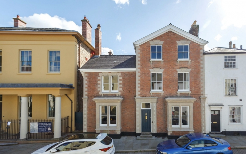
Mid C19 front in two parts.
Tall 3 storey 2 window gabled range forward to right, 2 storey 1 window lateral range to left.
Red brick with painted stone dressings, slate roofs, brick stacks, barge boards, quoins with angle pilasters to ground floor. Lintels with keystones, cill brackets, bipartite window to left, small bays to ground floor. pilastered door piece in centre.
Included for group value.
External links are from the relevant listing authority and, where applicable, Wikidata. Wikidata IDs may be related buildings as well as this specific building. If you want to add or update a link, you will need to do so by editing the Wikidata entry.


Other nearby listed buildings
