Approximate Location Map
Large Map »
Latitude: 51.7469 / 51°44'48"N
Longitude: -3.3746 / 3°22'28"W
OS Eastings: 305197
OS Northings: 206247
OS Grid: SO051062
Mapcode National: GBR HN.15W4
Mapcode Global: VH6CY.GCB6
Plus Code: 9C3RPJWG+Q5
Entry Name: Merthyr Christian Centre
Listing Date: 16 October 1978
Last Amended: 13 January 1988
Grade: II
Source: Cadw
Source ID: 11426
Building Class: Religious, Ritual and Funerary
Also known as: Merthyr Tydfil Synagogue
ID on this website: 300011426
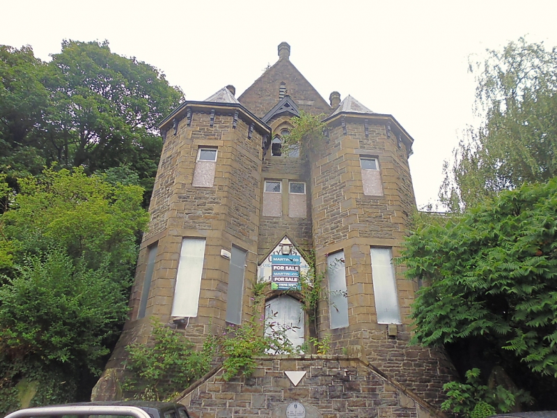
Location: On an elevated site against the hillside with gabled front closing the view up Church Street.
County: Merthyr Tydfil
Community: Town (Y Dref)
Community: Town
Locality: Thomastown
Built-Up Area: Merthyr Tydfil
Traditional County: Glamorgan
Tagged with: Synagogue Gothic Revival
Built as a Synagogue, 1872-5, in heavy Northern Gothic style.
Snecked rubble facings with ashlar bands and dressings; slate roofs with red tiled ridges and finials. Crowning gable with polygonal finials and narrow louvred openings. 5-light window with lancets and blocked lights over 3-storey transverse n ex. Narrow entrance gable, with plate-traceried window under scissor-braced bargeboards, flanked by two 2-storey polygonal staircase turrets with conical roofs on eaves brackets, narrow windows with stone lintels. Double flight of steps with stone piers, iron balustrade (partly missing) and iron lamp standards rises to gabled doorway with dripstone.
Included primarily for historic interest as the oldest remaining Synagogue building in Wales.
External links are from the relevant listing authority and, where applicable, Wikidata. Wikidata IDs may be related buildings as well as this specific building. If you want to add or update a link, you will need to do so by editing the Wikidata entry.


Other nearby listed buildings
