History in Structure

Sunny Bank

A Grade II Listed Building in Town (Y Dref), Merthyr Tydfil

More Photos »
Approximate Location Map
Large Map »

Coordinates

Latitude: 51.7466 / 51°44'47"N

Longitude: -3.3744 / 3°22'27"W

OS Eastings: 305211

OS Northings: 206218

OS Grid: SO052062

Mapcode National: GBR HN.15YF

Mapcode Global: VH6CY.GCGD

Plus Code: 9C3RPJWG+J6

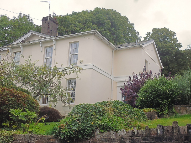
Entry Name: Sunny Bank

Listing Date: 13 January 1988

Last Amended: 13 January 1988

Grade: II

Source: Cadw

Source ID: 11428

Building Class: Domestic

ID on this website: 300011428

Location: High above road behind walled garden.

County: Merthyr Tydfil

Community: Town (Y Dref)

Community: Town

Locality: Thomastown

Built-Up Area: Merthyr Tydfil

Traditional County: Glamorgan

Tagged with: Architectural structure

Find accommodation in
Merthyr Tydfil

History

Shown on 1850 Tithe Map of Merthyr Tydfil.

Exterior

2-storey, 4-bay Regency stucco pair, hipped, tiled and slated roof.

Central pediment and rendered chimney over wide eaves with arched brackets; sill band. Sash windows with glazing bars to ground-floor right only, modern small-pane windows to left. Set-back transverse-gabled entrance bays with Tuscan doorcases (modern porch to left).

External Links

External links are from the relevant listing authority and, where applicable, Wikidata. Wikidata IDs may be related buildings as well as this specific building. If you want to add or update a link, you will need to do so by editing the Wikidata entry.

Recommended Books

Other nearby listed buildings

  • II Bryn Heulog
    High above road behind walled garden.
  • II Merthyr Christian Centre
    On an elevated site against the hillside with gabled front closing the view up Church Street.
  • II The Rectory
    Detached T-plan house set on hillside with road curving forward from right above.
  • II Primrose Hill
    Detached house at top end of Church Street where the road turns at right-angles into Bryntirion Road.
  • II Springfield Villa
    Uphill from Rectory and reached by a diagonal roadway from Bryntirion Road near Sandbrook House. Detached in walled garden.
  • II Former Unitarian Chapel
    Set in terraced row close to corner with Church Street.
  • II Newton House
    Pair of terraced houses stepped in slope towards Church Street.
  • II Boer War Memorial & Railings
    Set away from road on a modelled, grassy hillside overlooking the town centre; recreation ground to N.

BritishListedBuildings.co.uk is an independent online resource and is not associated with any government department. All government data published here is used under licence. Please do not contact BritishListedBuildings.co.uk for any queries related to any individual listed building, planning permission related to listed buildings or the listing process itself.

British Listed Buildings is a Good Stuff website.