Approximate Location Map
Large Map »
Latitude: 51.5518 / 51°33'6"N
Longitude: -3.213 / 3°12'46"W
OS Eastings: 315995
OS Northings: 184358
OS Grid: ST159843
Mapcode National: GBR HW.FJJV
Mapcode Global: VH6F0.8896
Plus Code: 9C3RHQ2P+PR
Entry Name: Castell Morgraig
Listing Date: 28 January 1963
Last Amended: 18 February 1999
Grade: II
Source: Cadw
Source ID: 13540
Building Class: Defence
Also known as: Castell Morgraig
ID on this website: 300013540
Location: Located approximately 100m E of the car park of the Travellers' Rest Inn. On a steep scarp, the ground falling sharply to the N and S, with good visibility over the road from Cardiff to Caerphilly.
County: Caerphilly
Town: Caerphilly
Community: Caerphilly (Caerffili)
Community: Caerphilly
Locality: Thornhill
Traditional County: Glamorgan
Tagged with: Castle
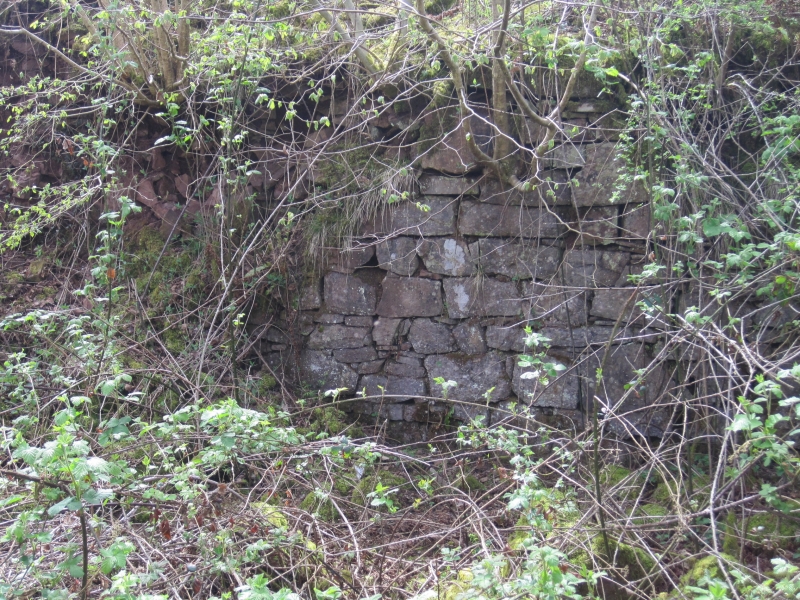
Medieval castle, built between 1243 and 1267 on the border of the English Lordship of Cardiff and Senghenydd. It was certainly built by 1267 when Lord Gilbert de Clare of Glamorgan had taken control of Senghenydd and the construction of Caerphilly Castle was about to begin. The form of the castle is unusual and has no comparisons elsewhere: the keep and gateway are archaic, whilst the flanking towers and dressings are unlikely to be earlier than the mid C13. Debate has centred on whether the castle was built by the Welsh Lords of Senghenydd, or by the Norman Lords of Glamorgan. The most likely contenders are Gruffydd ap Rhys (1256-67) or Earl Richard de Clare (1243-62). Another possibility is that it was built by the former and taken over by the latter. It may have been a border garrison housing small cavalry units. In 1630 the castle was owned by Sir Edward Lewis of Van, and subsequently the Plymouth Estate. The castle was excavated in 1903-4 and it was concluded that the castle had never been completed, although it stood above 1st floor level.
Irregular pentagonal curtain wall with towers at 4 corners and a keep at the 5th corner. Entrance to W, with later access cut through to E. Thick walls of roughly coursed conglomerate stone, standing 1-3m high. The dressings are said to have been of Sutton stone. The keep is opposite the W entrance and adjacent to the later E entrance. It is square, larger than the towers, but most of the E wall is missing. The massive towers have rounded ends with splayed side walls. The remains of the doorways which led into them from the courtyard survive in some cases. The S towers have circular basements, but these were retaining structures to provide support on a steep scarp. Low indefinable earthworks in courtyard. There is said to have been a stone base for a timber staircase against the W curtain wall which led to the upper floor. The stone for constructing the castle was quarried at the site, leaving distinctive earthworks along the scarp of the hill.
Listed for its surviving medieval fabric, and for its historic interest as a castle of unusual plan-form.
Scheduled Ancient Monument GM031.
External links are from the relevant listing authority and, where applicable, Wikidata. Wikidata IDs may be related buildings as well as this specific building. If you want to add or update a link, you will need to do so by editing the Wikidata entry.


Other nearby listed buildings
