Approximate Location Map
Large Map »
Latitude: 51.5682 / 51°34'5"N
Longitude: -3.1876 / 3°11'15"W
OS Eastings: 317780
OS Northings: 186153
OS Grid: ST177861
Mapcode National: GBR HX.DJWM
Mapcode Global: VH6DT.PVP5
Plus Code: 9C3RHR96+7W
Entry Name: Lime Kilns on Van Road
Listing Date: 12 August 1993
Last Amended: 5 March 1999
Grade: II
Source: Cadw
Source ID: 13589
Building Class: Industrial
ID on this website: 300013589
Location: Located in an overgrown area immediately adjacent to south side of Van Road, east of a track to Tyn-y-parc.
County: Caerphilly
Community: Rudry (Rhydri)
Community: Rudry
Locality: Van Road
Built-Up Area: Caerphilly
Traditional County: Glamorgan
Tagged with: Lime kiln
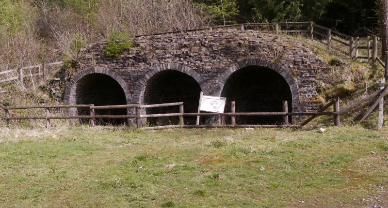
Mid C19 lime kilns first shown on 1883 Ordnance Survey, possibly serving a small quarry on the N side. Lime kilns were widely used in Britain from the C17 to the C20 to burn limestone for use as a fertiliser and in mortar. Many small banks of kilns were built in the late eighteenth and nineteenth centuries near roads or other transport routes, and usually close to quarries. This group is of typical scale and construction for a mid nineteenth-century kiln bank, while its large kiln chamber with 2 draw holes is unusual but is found elsewhere in the district (c.f. Pen-y-bryn, Eglwysilian).
A kiln bank sited on sloping ground in order to utilise the natural gradient for charging at the top and drawing at the bottom. The walls were original faced with hammer-dressed stone, most of which is now robbed out, leaving core stonework exposed. On the downhill side are 3 semi-circular draw arches. The arches are infilled with spoil, except on the R side where the cast iron lintel above the draw hole remains visible.
At the charging level is a single circular filling hole and a second much wider filling hole with straight sides and round ends, probably made by combining 2 former circular kilns. This larger kiln is therefore served by 2 draw holes.
Included as a good example of a type of small industrial structure once common in the area.
External links are from the relevant listing authority and, where applicable, Wikidata. Wikidata IDs may be related buildings as well as this specific building. If you want to add or update a link, you will need to do so by editing the Wikidata entry.


Other nearby listed buildings
