Approximate Location Map
Large Map »
Latitude: 51.7253 / 51°43'30"N
Longitude: -3.0728 / 3°4'21"W
OS Eastings: 325999
OS Northings: 203495
OS Grid: SO259034
Mapcode National: GBR J2.2HST
Mapcode Global: VH79K.PWDS
Plus Code: 9C3RPWGG+4V
Entry Name: The Big Arch
Listing Date: 13 September 1994
Last Amended: 28 July 1997
Grade: II
Source: Cadw
Source ID: 14871
Building Class: Transport
ID on this website: 300014871
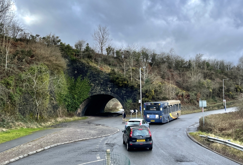
Location: Located next to the B4246 and carries a disused railway embankment across a disused railway line now a track. The arch forms the visual and actual gateway to the former British Ironworks area.
County: Torfaen
Town: Pontypool
Community: Abersychan
Community: Abersychan
Locality: The British
Built-Up Area: Abersychan
Traditional County: Monmouthshire
Tagged with: Architectural structure Railway bridge
The 'Big Arch' was constructed in 1879 to carry the Monmouthshire Railway to a junction with the London and North-Western Railway Blaenavon branch. The junction was immediately north of this bridge and led to a jointly owned stretch of line running through Abersychan and Talywain station to Garndiffaith junction. A low level branch of the Monmouthshire Railway left the line south east of the junction to serve the main level of the British Ironworks, which operated from 1827 -1883. This branch crossed back under the Monmouthshire Railway's embankment which made the construction of this tunnel necessary. The height of the embankment, which was the result of the already existing London and North-Western line, meant the construction of this unusually long arch and tall revetment walls. The Talywain branch was opened from Pontnewynydd on 18/9/1879. It was built by the Monmouthshire Railway and Canal Company but was worked from the start by the Great Western Railway and the companies were formally amalgamated 1/8/1880. It was closed to traffic on 3/5/1980.
Constructed of sandstone and brick. The bridge has a semi-circular arch 11m wide of five rings of engineering brick. The arch is 36m long and was constructed as a cut-and-cover tunnel. The revetment walls forming the portals are of bull-nosed sandstone on an unusual L-plan to support the embankment, which is on a skew to the arch. The corners of the L's are rounded and the walls are slightly battered. They slope steeply to the ground from apexes near the track bed level.
Included for its historical interest, as a good example of railway engineering, and for its group value with the former British Ironworks offices and workshops, and the pumping Engine house of British Colliery.
External links are from the relevant listing authority and, where applicable, Wikidata. Wikidata IDs may be related buildings as well as this specific building. If you want to add or update a link, you will need to do so by editing the Wikidata entry.


Other nearby listed buildings
