Latitude: 52.9198 / 52°55'11"N
Longitude: -4.2238 / 4°13'25"W
OS Eastings: 250584
OS Northings: 338136
OS Grid: SH505381
Mapcode National: GBR 5L.N0FP
Mapcode Global: WH55K.2VXZ
Plus Code: 9C4QWQ9G+WF
Entry Name: Morannedd Cafe
Listing Date: 12 December 1994
Last Amended: 12 December 1994
Grade: II
Source: Cadw
Source ID: 15348
Building Class: Commercial
ID on this website: 300015348
Location: At the eastern end of the Esplanade, close to the railway line.
County: Gwynedd
Community: Criccieth (Cricieth)
Community: Criccieth
Built-Up Area: Criccieth
Traditional County: Caernarfonshire
Tagged with: Architectural structure
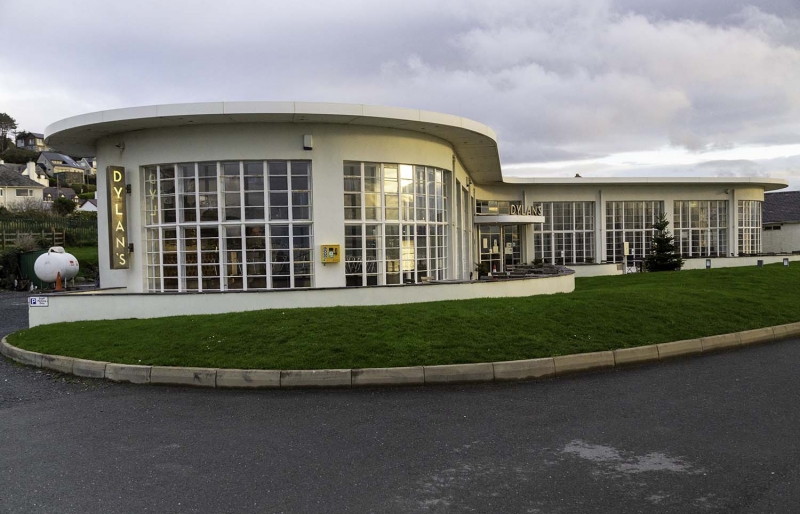
Plans were submitted for the building of this beach cafe in 1948, with Clough Williams Ellis as consulting architect.
Concrete construction with flat concrete roof reinforced with iron and carried with a bold overhand on a series of cast iron brackets. Single storeyed, the building is boomerang shaped, with the entrance in the centre, between the curved wings. Paired glazed doorways with glass-brick windows between and above them. Each wing has wide full-height windows articulated by a grid of metal glazing bars in the elevation facing the sea and curving round each curved end. The straighter rear walls are lit from windows set high up beneath the eaves.
A distinctive sea-side pavillion which is a rare essay in the International modern style by one of the leading Welsh architects of the C20.
External links are from the relevant listing authority and, where applicable, Wikidata. Wikidata IDs may be related buildings as well as this specific building. If you want to add or update a link, you will need to do so by editing the Wikidata entry.


Other nearby listed buildings