Approximate Location Map
Large Map »
Latitude: 52.949 / 52°56'56"N
Longitude: -3.9157 / 3°54'56"W
OS Eastings: 271385
OS Northings: 340788
OS Grid: SH713407
Mapcode National: GBR 5Z.L993
Mapcode Global: WH55P.T4KK
Plus Code: 9C4RW3XM+JP
Entry Name: House 100m SW of Bont Newydd
Listing Date: 1 February 1996
Last Amended: 1 February 1996
Grade: II
Source: Cadw
Source ID: 16863
Building Class: Domestic
ID on this website: 300016863
County: Gwynedd
Community: Ffestiniog
Community: Ffestiniog
Locality: Bont Newydd
Traditional County: Merionethshire
Tagged with: House
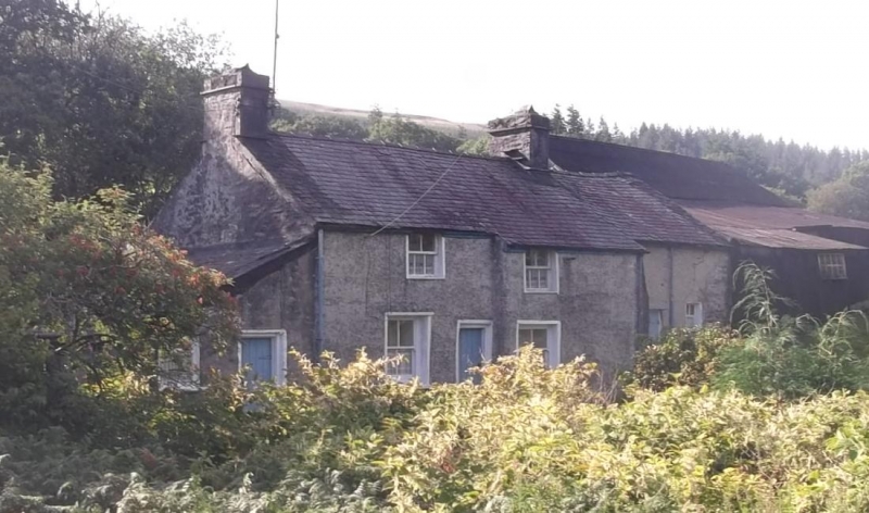
Exterior: Small vernacular farmhouse, probably of late C17 origin, raised and extended early C19 and c1900. Rendered facade; rubble construction on a boulder plinth; slate roof. The primary block (to the L) has a central entrance with flanking bays, that to the R slightly advanced. These have plain sashes to the ground floor and smaller sashes above, the lower triple-paned sections of which are early C19, and the plain upper sections of which are later replacements. To the R a recessed full-height early C19 service extension with plain entrance. c1900 lean-to to L with recessed entrance and modern window beyond; boarded doors throughout. Squat brick end chimneys to the primary block. The rear is unrendered.
The interior was not accessible at the time of survey (June 1995).
Adjoining to the R 2 early C20 corrugated iron agricultural buildings, set into the slope of the hill to the rear and side.
A vernacular farmhouse of early origins and retaining much character in a prominent road-side location.
External links are from the relevant listing authority and, where applicable, Wikidata. Wikidata IDs may be related buildings as well as this specific building. If you want to add or update a link, you will need to do so by editing the Wikidata entry.


Other nearby listed buildings
