History in Structure

Barn Cottage

A Grade II Listed Building in Glasbury, Powys

More Photos »
Approximate Location Map
Large Map »

Coordinates

Latitude: 52.0675 / 52°4'3"N

Longitude: -3.1808 / 3°10'50"W

OS Eastings: 319153

OS Northings: 241675

OS Grid: SO191416

Mapcode National: GBR YY.CZKH

Mapcode Global: VH6BH.T99C

Plus Code: 9C4R3R99+2M

Entry Name: Barn Cottage

Listing Date: 18 January 1996

Last Amended: 18 January 1996

Grade: II

Source: Cadw

Source ID: 17212

Building Class: Agriculture and Subsistence

ID on this website: 300017212

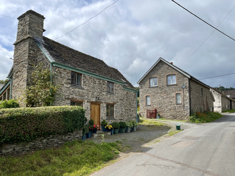
Location: Located in Llowes village, above Albert Cottages and opposite the turn to Llowes mill, set parallel to the road.

County: Powys

Community: Glasbury (Y Clas-ar-wy)

Community: Glasbury

Locality: Llowes

Traditional County: Radnorshire

Tagged with: Cottage

Find accommodation in
Llanigon

Exterior

Cottage, early C19, rubble stonework, once whitewashed, with a stone slate roof. Two bays, comprising a living room with an external gable stack, and service room at the N end. Central boarded door and timber 4-pane casement windows, all with timber lintels. Added lean-to at uphill end with boarded door and corrugated asbestos roof, slightly set back, containing storeroom. To rear, one small window to upper end room.

Interior

Matchboarded draught screen protecting the living room from the door.

Reasons for Listing

Included as a representative and largely unaltered example of a farm workers cottage of the early C19.

External Links

External links are from the relevant listing authority and, where applicable, Wikidata. Wikidata IDs may be related buildings as well as this specific building. If you want to add or update a link, you will need to do so by editing the Wikidata entry.

Recommended Books

Other nearby listed buildings

  • II 2 Albert Terrace
    Located at the centre of Llowes, the terrace is set end-on to the road to Painscastle.
  • II 3 Albert Terrace
    Located at the centre of Llowes, the terrace is set end-on to the road to Painscastle.
  • II 1 Albert Terrace
    Located at the centre of Llowes, the terrace is set end-on to the road to Painscastle.
  • II Former Mill
    In the centre of Llowes village adjacent to a minor road leading through the village to the north.
  • II Vicarage House
    Located on rising ground facing S, with a driveway leading down to the junction of the Moity Road with the realigned A.438.
  • II Old Vicarage
    The Old Vicarage is located in the village, 200m SW of the parish church, set in its own gardens, and facing the road to Moity and Gogia, and 150m from the main A.438 Brecon to Hereford road.
  • II Church of St Meilig
    The church is set in an oval churchyard at the centre of the small village, standing back from the A.438 Brecon to Hereford road.
  • II The Radnor Arms PH
    Located on the S side of the A.438 Hereford to Brecon road, which now separates the building from the village of Llowes.

BritishListedBuildings.co.uk is an independent online resource and is not associated with any government department. All government data published here is used under licence. Please do not contact BritishListedBuildings.co.uk for any queries related to any individual listed building, planning permission related to listed buildings or the listing process itself.

British Listed Buildings is a Good Stuff website.