History in Structure

Lychgate to W of St. Michael's Church

A Grade II Listed Building in Betws-y-Coed, Conwy

More Photos »
Approximate Location Map
Large Map »

Coordinates

Latitude: 53.0927 / 53°5'33"N

Longitude: -3.7999 / 3°47'59"W

OS Eastings: 279564

OS Northings: 356572

OS Grid: SH795565

Mapcode National: GBR 64.91G5

Mapcode Global: WH663.LJQD

Plus Code: 9C5R36V2+32

Entry Name: Lychgate to W of St. Michael's Church

Listing Date: 30 May 1996

Last Amended: 30 May 1996

Grade: II

Source: Cadw

Source ID: 17826

Building Class: Religious, Ritual and Funerary

ID on this website: 300017826

Location: Located on the W side of the roughly oval churchyard which is enclosed by low rubble walls and incorporates a secondary, late C19th, lychgate to the S.

County: Conwy

Community: Betws-y-Coed

Community: Betws-y-Coed

Built-Up Area: Betws-Y-Coed

Traditional County: Caernarfonshire

Tagged with: Lychgate

Find accommodation in
Betws-y-coed

Exterior

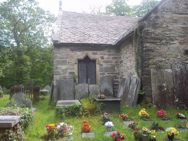
History: Dated 1756. Set into churchyard boundary to small late-medieval church built on probable ancient site.

Description: Simple rubble lychgate with E and W gables and old slatestone roof. There are simple openings at both ends with exposed timber lintels; that to the W (outer) is replaced, though its inner lintel is stopped-chamfered and bears the inscribed initials: RR RW, together with the date 1756 and some later, unconnected graffiti. Wide C19 boarded door with plain hinges. The E opening has an original, though un-inscribed outer lintel. Small rubble wall benches to sides; softwood purlins and rafters, some replaced, concreted floor.

Included as a dated, mid C18 lychgate, with group value with the church of St. Michael.

External Links

External links are from the relevant listing authority and, where applicable, Wikidata. Wikidata IDs may be related buildings as well as this specific building. If you want to add or update a link, you will need to do so by editing the Wikidata entry.

Recommended Books

Other nearby listed buildings

  • II* St Michael's Church
    Located on the W bank of the Afon Conwy, 100m E of Betws-y-Coed railway station.
  • II* St. Mary's Church
    Located immediately to the SW of the main road (A5) in the centre of the town.
  • II Bryn-y-Bont
    Prominently located immediately opposite the NE approach of the Pont-y-Pair; raised up on a revetted bank.
  • II* Pont-y-Pair
    Carrying the B5106 and fording the Afon Llugwy in the centre of the town.
  • II Plas Muriau
    Situated high above the Conwy Valley and reached from a lane east off the A470. Set in its own landscaped grounds and entered between gate-piers with ball finials and a timber gate.
  • II Milestone
    Located on the NE side of the main trunk road (A5) diagonally opposite Betws-y-Coed police station; set against a rubble wall.
  • II Beaver Grove House
    Located in its own grounds on the E bank of the Afon Conwy, approximately 200m N of the Waterloo Bridge and opposite Betws-y-Coed; accessed via a pair of gravelled drives running W from the main road.
  • I Waterloo Bridge
    Spanning the Afon Conwy and carrying the A5 from Betws-y-Coed to Pentrefoelas.

BritishListedBuildings.co.uk is an independent online resource and is not associated with any government department. All government data published here is used under licence. Please do not contact BritishListedBuildings.co.uk for any queries related to any individual listed building, planning permission related to listed buildings or the listing process itself.

British Listed Buildings is a Good Stuff website.