Approximate Location Map
Large Map »
Latitude: 53.0881 / 53°5'16"N
Longitude: -3.7989 / 3°47'56"W
OS Eastings: 279619
OS Northings: 356050
OS Grid: SH796560
Mapcode National: GBR 64.9FPB
Mapcode Global: WH663.MM6Z
Plus Code: 9C5R36Q2+6C
Entry Name: Milestone
Listing Date: 30 May 1996
Last Amended: 30 May 1996
Grade: II
Source: Cadw
Source ID: 17828
Building Class: Transport
ID on this website: 300017828
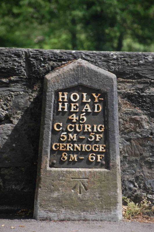
Location: Located on the NE side of the main trunk road (A5) diagonally opposite Betws-y-Coed police station; set against a rubble wall.
County: Conwy
Town: Betws-y-Coed
Community: Betws-y-Coed
Community: Betws-y-Coed
Built-Up Area: Betws-Y-Coed
Traditional County: Caernarfonshire
Tagged with: Milestone
Following the Act of Union in 1801, a programme to improve the roads between the two capital cities of London and Dublin was initiated. In 1811 Thomas Telford was commissioned to undertake a survey of the roads between London and Holyhead and in 1817 began work on the northern stretch of the road at Shrewsbury. As well as overseeing the work, Thomas Telford also designed every detail of the road, and this milestone is one of a number designed for it. Milestones between Bangor and Cernioge were erected in the period between 1825 and February 1827.
Dressed Anglesey limestone slab, with shallow triangular head and raking chamfered sides. Cast iron inset plate, white lettering on black reading: HOLY- / HEAD / 45 / C. CURIG / 5M - 5 F / CERNIOGE / 8M – 6F. Bench mark on stone below plate.
Has been relocated (with the road) upwards from its original position when the railway bridge was built.
Listed as a fine example of one of Telford's milestones retaining its cast iron plate.
External links are from the relevant listing authority and, where applicable, Wikidata. Wikidata IDs may be related buildings as well as this specific building. If you want to add or update a link, you will need to do so by editing the Wikidata entry.


Other nearby listed buildings
