Approximate Location Map
Large Map »
Latitude: 51.7338 / 51°44'1"N
Longitude: -4.6941 / 4°41'38"W
OS Eastings: 214060
OS Northings: 207335
OS Grid: SN140073
Mapcode National: GBR GF.3ZS0
Mapcode Global: VH2PD.LP87
Plus Code: 9C3QP8M4+G9
Entry Name: Walls and Kilns above Furnace Bank
Listing Date: 18 March 1997
Last Amended: 18 March 1997
Grade: II
Source: Cadw
Source ID: 18277
Building Class: Industrial
ID on this website: 300018277
Location: On high ground to the rear of Kilgetty Ironworks, on the W side of Pleasant Valley.
County: Pembrokeshire
Town: Kilgetty
Community: Kilgetty/Begelly (Cilgeti/Begeli)
Community: Kilgetty/Begelly
Locality: Kilgetty Ironworks
Built-Up Area: Stepaside
Traditional County: Pembrokeshire
Tagged with: Kiln
Kilgetty Ironworks was planned from 1846 by the Pembrokeshire Coal and Iron Company. Four, or possibly six, furnaces were anticipated. The works commenced production in 1849 with two furnaces, only one of which was then brought into blast. A year later production was halted due to an explosion. Grove Colliery was opened in 1856 to supply coal. Success was only moderate, and by 1861 the Company was in difficulties; in 1863 it was acquired by C H Vickerman and a brief period of prosperity commenced. In this heyday the works were pictured by M S Whatley. The furnaces were blown out in 1867, and Vickerman contemplated selling. For this purpose an inventory of the works was drawn up in 1872; James Carlton and the Bonville's Court Coal and Iron Company purchased them and brought in new investment. In 1873 a furnace was again in blast, but was blown out again a year later at a time of trade depression. The new owners went into liquidation in 1876 and the works closed in 1877. Vickerman, the main creditor, was able to buy the works back at a modest price. In 1888-9 the plant was dismantled and sold, but the buildings remained in workshop or storage use.
In the 1872 inventory "mine and limekilns" are described: there were two oval kilns of 3 to 6 m diameter and three circular kilns, located close to the top of the furnaces. The arrangements for calcining and, if required, lime burning, probably changed frequently. The reference to limekilns suggests that at Kilgetty the unusual, but not unknown, practice of using quicklime as some or all of the fluxing material may have been attempted.
At Kilgetty the ore used was the local argillaceous ore. Haematite is also found locally, and deposits of it are described in the inventory, although it appears to have been virtually untried. The inventory also indicates that the fuel used at one time, perhaps originally, was so-called "anthracite coke", a mixture of small anthracite with bituminous slack. The inventory refers to 29 coke ovens in three blocks in use in 1872.
In 1888, not long after closure of the ironworks, the Ordnance Survey shows two large oval kilns opposite to the furnaces and single small kiln in a detached position to the N. On the 1906 edition "limekilns" are shown and noted, and are probably still in use. However, they appear to be two circular and two oval kilns, whereas the present set consists of six similar circular kilns. It appears therefore the surviving kilns are a post-1906 rebuild, exploiting the convenient location with railway sidings at high and low levels.
The single oval kiln in isolation to the N shown in 1888 remains. This was probably a scotch kiln for calcining ore.
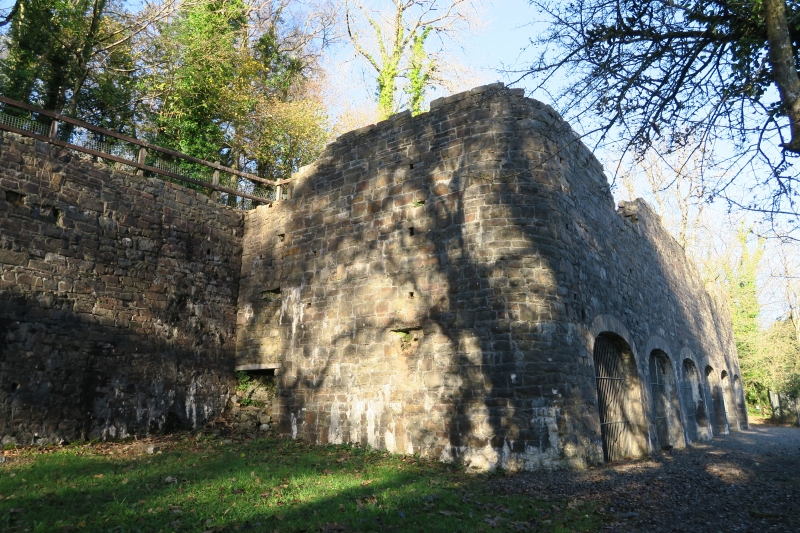
At the rear of the Furnace bank platform there is a high retaining wall extending for some distance N and S, built of local sandstone rubble. In 1888 and 1906 railway sidings are shown both above and below this retaining wall. On the platform in front of it the charging materials for the furnaces were stored and prepared.
At the N end of the platform there survives a single oval kiln or calcining oven with its access arch facing S to a vaulted space. The pit of this kiln or oven is a cubical space about 1.25 m square.
The limekilns are a set of six. They are built of the local sandstone, with firebrick linings. The front wall is battered, has rounded front corners, and survives to its full height; but the top is inaccessible. The kilns appear not to be bonded to the great retaining wall at the rear. The working arches are all similar, about 3 m in span, of elliptical form and constructed with special voussoir-shaped firebricks. One kiln contains a mass of lime. The interiors are ruinous. At the N side of the kilns is a small bothy for the workers with a doorway and a window.
Listed as the Furnace bank-top area of the Kilgetty Ironworks, with retaining walls and a rare surviving calcining kiln, all part of a remarkable surviving industrial group; also a good set of limekilns of early C20 date using the location after the closure of the ironworks.
Scheduled Ancient Monument Pe 418.
External links are from the relevant listing authority and, where applicable, Wikidata. Wikidata IDs may be related buildings as well as this specific building. If you want to add or update a link, you will need to do so by editing the Wikidata entry.


Other nearby listed buildings
