History in Structure

Hooped Grave Cover in Llangeinor churchyard

A Grade II Listed Building in Garw Valley (Cwm Garw), Bridgend

More Photos »
Approximate Location Map
Large Map »

Coordinates

Latitude: 51.5799 / 51°34'47"N

Longitude: -3.553 / 3°33'10"W

OS Eastings: 292489

OS Northings: 187924

OS Grid: SS924879

Mapcode National: GBR HF.CP0L

Mapcode Global: VH5H5.CKK6

Plus Code: 9C3RHCHW+XR

Entry Name: Hooped Grave Cover in Llangeinor churchyard

Listing Date: 30 July 1997

Last Amended: 30 July 1997

Grade: II

Source: Cadw

Source ID: 18636

Building Class: Religious, Ritual and Funerary

ID on this website: 300018636

Location: In Llangeinor churchyard, SE section, near front boundary wall.

County: Bridgend

Community: Garw Valley (Cwm Garw)

Community: Garw Valley

Locality: Llangeinor

Traditional County: Glamorgan

Tagged with: Grave

Find accommodation in
Llangeinor

History

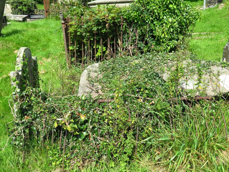
Unusual survival of a metal grave cover, possibly installed to prevent theft of bodies for medical purposes during C18 -19. It is a series of metal hoops fixed to a framework forming a semicircular grille and is modest in size compared to some stronger larger illustrated versions. Some anti body-snatching devices were used only temporarily and moved to new graves as needed. An alternative possible use is as a temporary grave cover, a development of the more customary wicker version. The modest headstone at top is now illegible; small footstone at opposite end. Churchyard has a number of unusual coffin shaped kerb graves with very small head and footstones.

Reasons for Listing

Listed as an unusual survival of a former burial practice and for group value with Church of St Cein.

External Links

External links are from the relevant listing authority and, where applicable, Wikidata. Wikidata IDs may be related buildings as well as this specific building. If you want to add or update a link, you will need to do so by editing the Wikidata entry.

Recommended Books

Other nearby listed buildings

  • II* Church of St Cein
    Situated on the hilltop approx 2 km NE Llangeinor, reached from the road that links Garw and Ogmore Valleys, centre of a small rural settlement.
  • II Tynton
    Reached up a steep lane from the main road, on the N edge of the village and E side of the valley.
  • II Paran Capel y Bedyddwr
    The chapel is set on the road from Bridgend to Ogmore Vale, on the N side of its junction with the A4093 to Gilfach Goch and Tonyrefail.
  • II Edwards monument in the graveyard of Paran Chapel
    The tomb is located approximately 4m SE of the Edwards chest tomb, and near the W side of the graveyard on the S side of Paran Chapel.
  • II Jenkins monument in the graveyard, Paran Chapel
    The monument stands in the enclosed graveyard approximately 4m S of the S wall of the chapel.
  • II Evans chest tomb in graveyard of Paran Chapel
    The tomb is set close to the S side of the Jenkins monument, S of the S wall of the chapel.
  • II Fox and Hounds PH
    The building stands at right angles to the main road, facing S over the start of a small road running W.
  • II Blackmill War Memorial
    Located at the cross roads at the centre of the hamlet, where the road dips and crosses the Ogmore River.

BritishListedBuildings.co.uk is an independent online resource and is not associated with any government department. All government data published here is used under licence. Please do not contact BritishListedBuildings.co.uk for any queries related to any individual listed building, planning permission related to listed buildings or the listing process itself.

British Listed Buildings is a Good Stuff website.