Latitude: 51.6883 / 51°41'17"N
Longitude: -5.158 / 5°9'28"W
OS Eastings: 181815
OS Northings: 203563
OS Grid: SM818035
Mapcode National: GBR G3.JPCM
Mapcode Global: VH1RW.KT1L
Plus Code: 9C3PMRQR+8R
Entry Name: West Blockhouse Fort
Listing Date: 10 December 1997
Last Amended: 10 December 1997
Grade: II*
Source: Cadw
Source ID: 19148
Building Class: Defence
ID on this website: 300019148
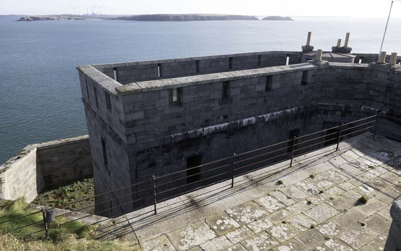
Maritime fort built in 1854-7 as part of the fortification of Milford Haven ordered by Lord Palmerston, to counteract the perceived threat from Napoleon III. The fortification of the whole Haven was initiated in 1850 (the defenses of Pembroke Naval Dockyard having begun in the 1840s). The first phase defending the Haven mouth comprised 3 open batteries with barrack blocks, at Thorne Island 1852-4, Dale Point 1853-7, and West Blockhouse Point, 1854-7, with also the gun-tower on Stack Rock, begun 1852. They were designed to counter sailing ships with smooth-bore cannon and were technically obsolete before being completed. The second inner group of forts followed from 1858, with forts at South Hook, Hubberston, and Popton. Stack Rock was also remodelled. Chapel Bay the last maritime fort dates from 1890. A chain of forts were proposed to cover the landward approaches but of these only Scoveston and Tenby were built. West Blockhouse and Dale Forts are both open gun-platforms, formerly armed with a mixture of smooth-bore and the more modern rifled muzzle-loading guns. New gun emplacements were built at five forts including West Blockhouse in 1904. While most of the forts were sold off between the wars, West Blockhouse was still armed. Sold to the Landmark Trust and converted to holiday accommodation in 1986 by Andrew Thomas of Thomas Jones Associates of Builth Wells.
West Blockhouse and East Blockhouse Points were so-named from two C16 gun emplacements built 1540-3 under orders from Thomas Cromwell.
Barrack-block and gun emplacement. Superbly executed tooled grey limestone walling with smooth limestone dressings and granite copings. Flat-roofed 3-sided, two-storey barrack block separated from cliff behind by a full-height stone-revetted ditch. Revetment walls return each side, stepping down to the front terrace, a low-walled gun emplacement. Barrack block comprises two wings at right angles and a short canted section between, which on the rear contains only the door reached by granite cantilevered steps down from the approach path, the steps giving onto a small granite platform from which a timber drawbridge crosses to the door and another similar flight of steps continue down to the ditch level. The approach has flight of 7 granite steps down between low limestone walls. Barrack block has flat roof with high coped parapet pierced with splayed musketry loops, small half-round cap-house to internal stair behind centre front with low chimney each side, two other chimneys on rear parapet, flanking canted short section. Ground floor walling is battered with raised plinth and band above, another band under parapet. Slightly raised rustication to windows and angles. Windows have stone sills carefully moulded to curved joint with jambs. Rear has 2 first floor small 12-pane sashes in each wing and timber studded door in centre with overlight and slate lintel, in square-headed recess with stone voussoirs. Datestone V.R. 1857 over. Tiny ground floor barred windows. Seaward facade has five musketry loops to each wing parapet, 3 to canted centre, one tiny window to centre of each floor of canted section. Wings have three first floor windows, inner one larger, left wing has 3 small ground floor windows, right wing only one, to left. 12-pane small sashes generally. Stone gutter spouts. End walls have one first floor sash.
Gun platform has 3 curved bastions projecting at angles, low ashlar walls, massively coped in granite. Wall steps up at right end to return to cliff. Small enclosed yard off with single-storey storehouse on right, flat parapet and 4 doors with stone lintels. Higher end wall with band and parapet, and one door.
Not available for inspection, said to have brick vaulted fire-proof ceilings.
Probably the best preserved of all the 'Palmerston Forts' around Milford Haven.
Scheduled Ancient Monument Pe 335.
External links are from the relevant listing authority and, where applicable, Wikidata. Wikidata IDs may be related buildings as well as this specific building. If you want to add or update a link, you will need to do so by editing the Wikidata entry.


Other nearby listed buildings