Approximate Location Map
Large Map »
Latitude: 51.7899 / 51°47'23"N
Longitude: -4.8918 / 4°53'30"W
OS Eastings: 200661
OS Northings: 214098
OS Grid: SN006140
Mapcode National: GBR CP.YF8Z
Mapcode Global: VH1RN.588P
Plus Code: 9C3QQ4Q5+X7
Entry Name: Picton Home Farm
Listing Date: 26 February 1998
Last Amended: 26 February 1998
Grade: II
Source: Cadw
Source ID: 19415
Building Class: Agriculture and Subsistence
ID on this website: 300019415
Location: 300 m E of the main gates to Picton Castle.
County: Pembrokeshire
Community: Uzmaston, Boulston and Slebech (Uzmaston, Boulston a Slebets)
Community: Slebech
Locality: Picton Park
Traditional County: Pembrokeshire
Tagged with: Architectural structure
A model farm of the early C19, the Home Farm of Picton, first appearing on the 1829 estate map. It was therefore possibly designed by Thomas Rowlands of Haverfordwest, who carried out numerous estate improvements for R B P Philipps in the period 1826-8.
There was formerly a dovecote in the centre of the farmyard, now demolished. The central part of the yard is now occupied by modern cattle sheds, and the NW corner of the original ranges of farm buildings has also been lost.
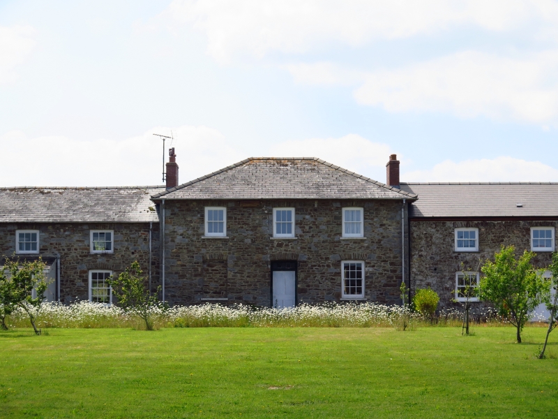
Farmhouse and buildings arranged in a square. The house faces S with a garden at its front, with low wall and railings. The house has lower extensions at E and W, the left one being a farmyard building and the right one an extension of the domestic accommodation. The ends of the E and W ranges are carried forward to the same building line as the house frontage, with gateways for farmyard access linking them to the house extensions. The plan of house and yard is symmetrical about the N/S axis. The original farmyard main entrance was at the centre of the N range, but is no longer in use.
All the buildings are in local sandstone rubble, more or less brought to courses, and do not appear to have been rendered. Limestone is informally used for some quoins and dressings. Slate roofs throughout, except where replaced by artificial slates on the house roof. Tiled ridges.
The house consists of a taller central part of three windows, except that the central window over the door is only a blind fenestration panel. Arched doorway centrally with a round-headed door. Four-pane sash windows under low segmental arches. Brick end-chimneys. At each end are symmetrical extensions with a lower roof level: at right a domestic three-window extension with a hipped end. The upper window on the E end face is blind; at W a building in farmyard use with similar elevation and roof. In the SE corner of the latter is a malting kiln with a plastered room (for grain) above. This extension, which does not communicate internally with the house, was probably accommodation for farm servants. Rounded engaged gatepiers link the E extension to the flanking range of farm buildings. On the rear elevation (facing the farmyard) the central three-window range is also advanced. Twelve-pane windows with hornless sashes above and below. Six-pane hornless-sash windows above in the 4-window wings.
The farmyard ranges at E and W of the yard are symmetrically similar, with six cartsheds each side at the N end facing the yard. These have low segmental arches. There are two staircases in the E range. These ranges are now used mostly as cattle sheds, with some workshops.
The N range has an architecturally composed N elevation (indicating the original main farmyard entrance) with alternating giant square and round headed openings. This was linked to the side ranges by buttressed corner buildings, now unroofed or demolished.
Listed as a fine example of an early C19 model farm probably contemporary with the many Picton estate improvements carried out by R B P Philipps in the late 1820s.
External links are from the relevant listing authority and, where applicable, Wikidata. Wikidata IDs may be related buildings as well as this specific building. If you want to add or update a link, you will need to do so by editing the Wikidata entry.


Other nearby listed buildings
