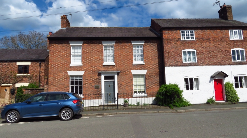
Admiralty House
A Grade II Listed Building in Willington Worthenbury, Wrexham
Coordinates
Latitude: 53.0096 / 53°0'34"N
Longitude: -2.8661 / 2°51'58"W
OS Eastings: 341981
OS Northings: 346159
OS Grid: SJ419461
Mapcode National: GBR 7C.GD90
Mapcode Global: WH896.YMB4
Plus Code: 9C5V245M+RG
Entry Name: Admiralty House
Listing Date: 7 May 1998
Grade: II
Source: Cadw
Source ID: 19769
Building Class: Domestic
ID on this website: 300019769
Location: Located on the north side of the main road through Worthenbury (B 5069) shortly after its junction with Church Road and adjacent to The Malt House. Set back behind iron-railed narrow forecourt.
County: Wrexham
Town: Wrexham
Community: Willington Worthenbury
Community: Willington Worthenbury
Locality: Worthenbury
Traditional County: Flintshire
Tagged with:
House
History
Early to mid C19 late Georgian house (shown on Tithe Map).
Exterior
Two-storey brick house under slate roof; brickwork laid to form distinctive diaper pattern formed by light and dark brick. Set back behind iron-railed narrow forecourt. Centrally planned facade around central doorcase with wooden reveals and Gothick lozenges to the frieze and rectangular fanlight. Six-panelled door with fielded upper panels. Five recessed twelve-paned wooden sash windows with glazing bars. Brick chimney stack to west gable end. Rendered plinth and lintels.
Reasons for Listing
Listed together with The Malt House and adjacent cottages as a prominent historic group in the centre of the village.
External Links
External links are from the relevant listing authority and, where applicable, Wikidata.
Wikidata IDs may be related buildings as well as this specific building. If you want to add or update a link, you
will need to do so by editing the Wikidata entry.
Recommended Books
Other nearby listed buildings
-
II
The Malt House including attached cottage to right
Prominently located to the north side of the main road through Worthenbury (B 5069) to the east of, and stepped forward from the adjoining Admiralty House.
-
II
Shop Cottage
Located in the centre of the village on the north side of the main road (B 5069) and attached to the former Post Office and Malt House.
-
I
Parish Church of St Deiniol
Located to the west of the centre of the village, a short distance along Church Road, within a walled graveyard. Fine views of the church across open meadows on the approach to the village from the s
-
II
Worthenbury Bridge
Located on the main road into Worthenbury from Bangor-is-y-coed.
-
II
The Old Rectory
Located in its own grounds off Mulsford Lane, after its junction with the main road through Worthenbury, the B 5069. The Old Rectory is set behind cast-iron Gothic style railings to the top of a low
-
II
The Manor and Quinton
Situated off the main road through Worthenbury (B 5069) shortly before Worthenbury Bridge with views towards Hollybush Lane to the south. It is reached by a short private drive and secluded in its ow
-
II
Frog Lane Cottage (West)
Located on the south side of Frog Lane (B 5069) in its own garden and set back from the road behind a low brick wall with iron gate and stone piers.
-
II
Bowling Bank Farmhouse including attached farm range to west
Located on the north side of Mulsford Lane which is a turning off the south of the B 5069 just after the centre of Worthenbury. The farmhouse entrance is through its cobbled farmyard.