History in Structure

Roadsign SE of Bogdadle

A Grade II Listed Building in Buan, Gwynedd

More Photos »
Approximate Location Map
Large Map »

Coordinates

Latitude: 52.8886 / 52°53'18"N

Longitude: -4.5105 / 4°30'37"W

OS Eastings: 231189

OS Northings: 335302

OS Grid: SH311353

Mapcode National: GBR 56.Q2SH

Mapcode Global: WH44G.PNBD

Plus Code: 9C4QVFQQ+CQ

Entry Name: Roadsign SE of Bogdadle

Listing Date: 15 July 1998

Last Amended: 15 July 1998

Grade: II

Source: Cadw

Source ID: 20141

Building Class: Transport

ID on this website: 300020141

Location: Situated on N side of B4415, at road junction with lane to Madryn 200m SE of Bodgadle Farm and some 1.5 km W of Rhydyclafdy.

County: Gwynedd

Town: Pwllheli

Community: Buan

Community: Buan

Locality: Rhydyclafdy

Traditional County: Caernarfonshire

Tagged with: Traffic sign

Find accommodation in
Penrhos

History

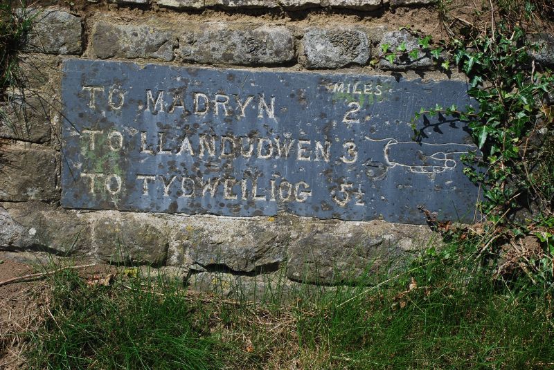
Later C19 direction indicator of a type found on B4415 also at Inkerman Bridge.

Exterior

Direction indicator, horizontal grey slate slab set in masonry, with distinctive hand and pointing finger, as on milestone at Pont Llidiard-y-dwr (Inkerman Bridge). Incised capital lettering painted white: MILES TO MADRYN 2, TO LLANDUDWEN 3, TO TYDWEILIOG, 5 1/2.

Reasons for Listing

Included as distinctive mile-marker, part of the series of milestones and signs on the B4415.

External Links

External links are from the relevant listing authority and, where applicable, Wikidata. Wikidata IDs may be related buildings as well as this specific building. If you want to add or update a link, you will need to do so by editing the Wikidata entry.

Recommended Books

Other nearby listed buildings

  • II Neuadd Bogdadle
    Situated some 400m NW of the B4415 road, N of Bodgadle on lane to Madryn.
  • II Milestone
    Situated on the N side of the B4415 road. Opposite entrance to Tynewydd Farm. Some 2 km W of Rhydyclafdy.
  • II Ty Isaf (NW Cottage)
    Situated 700m S of the B4415 road, and approx 1.4 km WSW of the village of Rhydyclafdy.
  • II Ty Isaf (SE Cottage)
    Situated 700m S of the B4415 road, and approx 1.4 km WSW of the village of Rhydyclafdy.
  • II Gallt-y-beren
    Situated some 100m N of the B4415 road, and some 700m NW of the village of Rhydyclafdy.
  • II Tyn-y-coed Isaf
    Situated some 1.1 km NW of the B4415 road, off lane to Madryn, NW of Bodgadle.
  • II Church of St Michael
    Situated some 600m SE of the B4415 road, approx 2.4 km W SW of the village of Rhydyclafdy.
  • II Capel Rhydyclafdy
    Situated next to B4415 road on the W side of the village of Rhydyclafdy.

BritishListedBuildings.co.uk is an independent online resource and is not associated with any government department. All government data published here is used under licence. Please do not contact BritishListedBuildings.co.uk for any queries related to any individual listed building, planning permission related to listed buildings or the listing process itself.

British Listed Buildings is a Good Stuff website.