Approximate Location Map
Large Map »
Latitude: 51.7366 / 51°44'11"N
Longitude: -4.3063 / 4°18'22"W
OS Eastings: 240847
OS Northings: 206724
OS Grid: SN408067
Mapcode National: GBR GP.TL6D
Mapcode Global: VH3M2.9MT3
Plus Code: 9C3QPMPV+JF
Entry Name: Wall along S side of churchyard
Listing Date: 28 July 1998
Last Amended: 28 July 1998
Grade: II
Source: Cadw
Source ID: 20191
Building Class: Religious, Ritual and Funerary
ID on this website: 300020191
Location: Situated on N side of Lady Street, between Parish Room and track to No 17 Lady Street.
County: Carmarthenshire
Town: Kidwelly
Community: Kidwelly (Cydweli)
Community: Kidwelly
Locality: Kidwelly/Cydweli
Built-Up Area: Kidwelly
Traditional County: Carmarthenshire
Tagged with: Churchyard wall
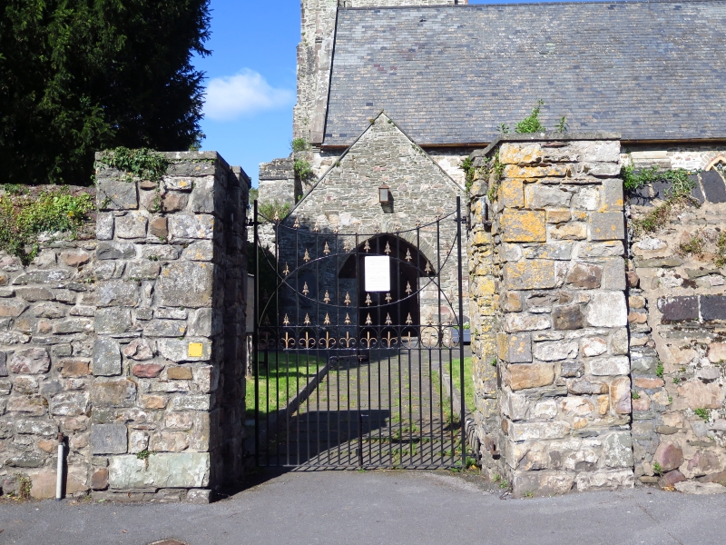
Late C18 to early C19 churchyard wall, built using industrial slag from mineral smelting.
Rubble stone wall, some 2m high to road, with band of squared slag blocks at mid height, and slag block coping of rounded triangular section. 14m from parish room to churchyard gate, with square rubble piers and C20 iron gates. 43m to upper gateway with square rubble piers, stone caps and earlier C19 iron gates with scrolled finials. Short rebuilt length to right of gateway.
Listed for group value with the Church of St Mary, and of interest for the use of industrial slag.
External links are from the relevant listing authority and, where applicable, Wikidata. Wikidata IDs may be related buildings as well as this specific building. If you want to add or update a link, you will need to do so by editing the Wikidata entry.


Other nearby listed buildings
