Approximate Location Map
Large Map »
Latitude: 51.7333 / 51°44'0"N
Longitude: -4.3223 / 4°19'20"W
OS Eastings: 239730
OS Northings: 206399
OS Grid: SN397063
Mapcode National: GBR GP.BV8P
Mapcode Global: VH3M2.1PBL
Plus Code: 9C3QPMMH+83
Entry Name: Kidwelly Quay
Listing Date: 28 July 1998
Last Amended: 28 July 1998
Grade: II
Source: Cadw
Source ID: 20201
Building Class: Maritime
ID on this website: 300020201
Location: On the Gwendraeth Fach. Reached along a by-road running W from level crossing to SW of town centre.
County: Carmarthenshire
Town: Kidwelly
Community: Kidwelly (Cydweli)
Community: Kidwelly
Locality: Kidwelly Quay
Built-Up Area: Kidwelly
Traditional County: Carmarthenshire
Tagged with: Wharf
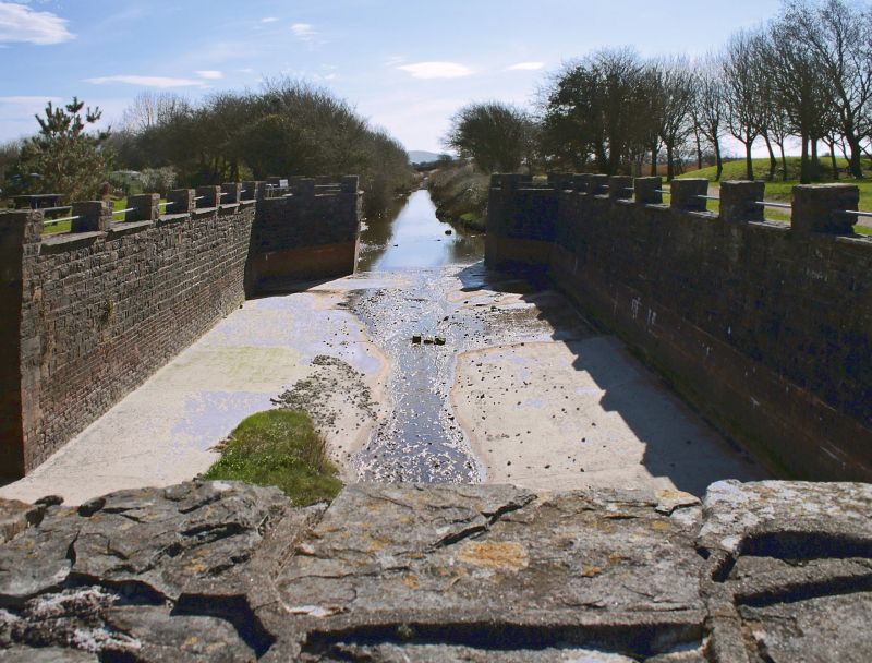
Built c1768 by Thomas Kymer to export anthracite brought down by his canal from the Gwendraeth Fawr. Trade declined after 1800 because of silting and the opening of Burry Port harbour in 1832. In 1873 a branch of the Burry Port & Gwendraeth Valley Railway was laid on the canal towpath. Occasional shipments of coal continued until final closure of Kidwelly Quay in 1934. In 1980s, repairs were done to the dock walls and the canal basin was remade.
Pair of coursed rubble quays linked around a small tidal dock leading off the E side of the Gwendraeth Fach estuary. The larger, rectangular E quay lies at the end of Quay Road with the reconstructed canal basin adjoining on inland direction. Approx 5m high walls with battered profile rise from the estuary mud and continue with curved angles into the dock and return at nearly straight angles to meet W quay. This is narrower and rounded at outer end from where masonry walls run for a short distance into the natural foreshore. The top 2m are recently rebuilt with proud pointing and act as uncapped parapets to wharfage space on top of the quays; the larger quay was formerly accessed by railway sidings. There is one set of steps let into the upper E side of the dock. A modern ramp leads down to the river on W side of the quay.
A substantial masonry dock of C18 date with important historical connections to Kymer's Canal, the earliest canal of any length in Wales.
External links are from the relevant listing authority and, where applicable, Wikidata. Wikidata IDs may be related buildings as well as this specific building. If you want to add or update a link, you will need to do so by editing the Wikidata entry.


Other nearby listed buildings
