History in Structure

Yr Hen Ysgol

A Grade II Listed Building in Pentrefoelas, Conwy

More Photos »
Approximate Location Map
Large Map »

Coordinates

Latitude: 53.05 / 53°2'59"N

Longitude: -3.6838 / 3°41'1"W

OS Eastings: 287229

OS Northings: 351629

OS Grid: SH872516

Mapcode National: GBR 68.CZLN

Mapcode Global: WH66C.DL1N

Plus Code: 9C5R28X8+XF

Entry Name: Yr Hen Ysgol

Listing Date: 19 October 1998

Last Amended: 19 October 1998

Grade: II

Source: Cadw

Source ID: 20579

Building Class: Education

ID on this website: 300020579

Location: The building lies alongside the road immediately W of the bridge at the sharp bend.

County: Conwy

Town: Pentrefoelas

Community: Pentrefoelas

Community: Pentrefoelas

Traditional County: Denbighshire

Tagged with: School building

Find accommodation in
Pentrefoelas

History

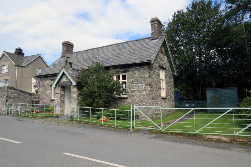
Built as a National School in 1852 at the expense of Col C W Wynne Finch of Voelas.

Exterior

Rubble stonework with a slate roof. An 'L'-plan building symmetrical to the front, with a central open-fronted porch crowned by a simple small bellcote. Stone lintel. The inner door is studded and has decorative hinges. Tall timber cross windows, the frames having staff mouldings. Gable stacks. A rear wing in a similar style with a lean-to at the gable end, and a lean-to service building set in the angle on the W side. The E window has been extended down to provide a door, with an external ramp.

Interior

The interior of the front block is divided by a timber screen. Arched opening into the rear wing.

Reasons for Listing

Included as a virtually unaltered, small, mid C19 school.

External Links

External links are from the relevant listing authority and, where applicable, Wikidata. Wikidata IDs may be related buildings as well as this specific building. If you want to add or update a link, you will need to do so by editing the Wikidata entry.

Recommended Books

Other nearby listed buildings

  • II Pont-yr-odyn
    The bridge occurs in Pentrefoelas village at the bend at the top of the main street, rising from its junction with the A5 Holyhead Road.
  • II Y golchdy (also known as Yr hen ladd-dy)
    The building stands at the top of the hill rising from the junction with the Holyhead Road, backing on to the small brook.
  • II Parish Church
    The church stands on the E side of the road at the top of the rise from its junction with the A5 Holyhead Road.
  • II Bronallt
    The row of estate cottages form a block fronting the Nebo Road on the E side climbing towards the church, and continuing the line established by Nos 1 and 2.
  • II Foelas Arms Hotel
    The hotel stands in the NW quadrant of the crossroads at the centre of Foelas, and extending at the side along the B5113 Nebo Road.
  • II Dolywen
    The row of estate cottages form a block fronting the Nebo Road on the E side climbing towards the church, and continuing the line established by Nos 1 and 2.
  • II Mill House
    The row of estate cottages form a block fronting the Nebo Road on the E side climbing towards the church, and continuing the line established by Nos 1 and 2.
  • II Bank House
    The two cottages are at the lower end of Nebo Road, by the junction with the Holyhead Road.

BritishListedBuildings.co.uk is an independent online resource and is not associated with any government department. All government data published here is used under licence. Please do not contact BritishListedBuildings.co.uk for any queries related to any individual listed building, planning permission related to listed buildings or the listing process itself.

British Listed Buildings is a Good Stuff website.