History in Structure

Pont-yr-odyn

A Grade II Listed Building in Pentrefoelas, Conwy

More Photos »
Approximate Location Map
Large Map »

Coordinates

Latitude: 53.0498 / 53°2'59"N

Longitude: -3.6834 / 3°41'0"W

OS Eastings: 287251

OS Northings: 351608

OS Grid: SH872516

Mapcode National: GBR 68.CZP9

Mapcode Global: WH66C.DL6T

Plus Code: 9C5R28X8+WJ

Entry Name: Pont-yr-odyn

Listing Date: 19 October 1998

Last Amended: 19 October 1998

Grade: II

Source: Cadw

Source ID: 20580

Building Class: Transport

ID on this website: 300020580

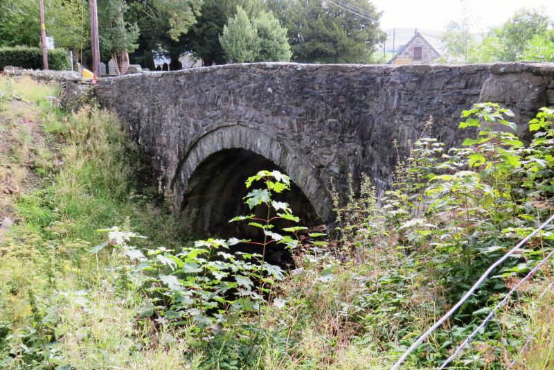
Location: The bridge occurs in Pentrefoelas village at the bend at the top of the main street, rising from its junction with the A5 Holyhead Road.

County: Conwy

Town: Pentrefoelas

Community: Pentrefoelas

Community: Pentrefoelas

Traditional County: Denbighshire

Tagged with: Architectural structure

Find accommodation in
Pentrefoelas

History

Built in the late C18 or early C19, and named after a corn drying kiln formerly situated nearby.

Exterior

The bridge carries the Nebo Road over a N tributary of the Afon Merddwr. A single semicircular arch spanning 6.7m formed with recessed rubble voussoirs and projecting regulating course flush with the spandrels and parapets over. The latter are curved on plan with flush stone copings, and terminate in square piers. The soffit of the arch is 3.1m above the water, and the carriageway is 5.4m between parapets of 0.45m width.

Reasons for Listing

Included as a good early road bridge of group value with other listed elements within the village.

External Links

External links are from the relevant listing authority and, where applicable, Wikidata. Wikidata IDs may be related buildings as well as this specific building. If you want to add or update a link, you will need to do so by editing the Wikidata entry.

Recommended Books

Other nearby listed buildings

  • II Yr Hen Ysgol
    The building lies alongside the road immediately W of the bridge at the sharp bend.
  • II Y golchdy (also known as Yr hen ladd-dy)
    The building stands at the top of the hill rising from the junction with the Holyhead Road, backing on to the small brook.
  • II Parish Church
    The church stands on the E side of the road at the top of the rise from its junction with the A5 Holyhead Road.
  • II Bronallt
    The row of estate cottages form a block fronting the Nebo Road on the E side climbing towards the church, and continuing the line established by Nos 1 and 2.
  • II Foelas Arms Hotel
    The hotel stands in the NW quadrant of the crossroads at the centre of Foelas, and extending at the side along the B5113 Nebo Road.
  • II Dolywen
    The row of estate cottages form a block fronting the Nebo Road on the E side climbing towards the church, and continuing the line established by Nos 1 and 2.
  • II Mill House
    The row of estate cottages form a block fronting the Nebo Road on the E side climbing towards the church, and continuing the line established by Nos 1 and 2.
  • II Bank House
    The two cottages are at the lower end of Nebo Road, by the junction with the Holyhead Road.

BritishListedBuildings.co.uk is an independent online resource and is not associated with any government department. All government data published here is used under licence. Please do not contact BritishListedBuildings.co.uk for any queries related to any individual listed building, planning permission related to listed buildings or the listing process itself.

British Listed Buildings is a Good Stuff website.