Approximate Location Map
Large Map »
Latitude: 51.8609 / 51°51'39"N
Longitude: -3.1908 / 3°11'26"W
OS Eastings: 318094
OS Northings: 218700
OS Grid: SO180187
Mapcode National: GBR YY.SWPM
Mapcode Global: VH6CG.NH0B
Plus Code: 9C3RVR65+8M
Entry Name: Tan-y-lan
Listing Date: 21 October 1998
Last Amended: 21 October 1998
Grade: II
Source: Cadw
Source ID: 20682
Building Class: Domestic
ID on this website: 300020682
Location: Located 1.1km along a narrow lane and then a track, which rises southwards from the Usk valley and the B4558 road. The house is sited end onto the slope.
County: Powys
Community: Llangattock (Llangatwg)
Community: Llangattock
Locality: Pen-y-Bryn
Traditional County: Brecknockshire
Tagged with: Farmhouse
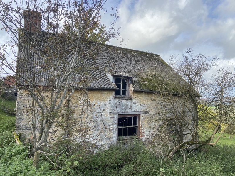
End-entry farmhouse built gable end onto the slope in C17 manner. The house is now uninhabited and is used as an animal shelter.
End-entry farmhouse of one and a half storeys, of limewashed rubble masonry under a corrugated asbestos sheet roof, probably formerly stone tiled. End stack rebuilt in brick. A single storey wing projects westwards from W wall of the house and is of larger masonry blocks. It has a slate roof and masonry gable stack. The entrance is on the R side of the S gable end and contains a planked door under a wooden lintel. The E wall of the house contains a wide 8-pane sash window in the centre under a timber lintel. Above it is a raking half dormer with a wooden 2-light casement window. To the R is a small 2-light casement window under a stone dripmould. All have stone sills. The N gable end has a wood-framed window in the gable under a stone dripmould, and a 2-light casement window below, offset to the R. The W wall contains a blocked doorway immediately next to the wing. To its right is a C20 window frame. A small 2-light casement window above is offset to the L. (Towards the R of the wall is a small brick lean-to with a corrugated asbestos sheet roof.) The wing has a doorway and window opening in the S side.
The hall is to the S with service room(s) to the N. The masonry fireplace at the S end was rebuilt or refaced in the mid C20. To its L is the entrance, with fireplace stairs to the R. The living room has narrow chamfered cross beams and the floor is currently of earth. The wing contains a cast iron fireplace and wash basin at the W end
Listed as a good example of a regional building type with characteristically early plan and siting.
Group value with the parallel Bank Barn at Tan-y-lan.
External links are from the relevant listing authority and, where applicable, Wikidata. Wikidata IDs may be related buildings as well as this specific building. If you want to add or update a link, you will need to do so by editing the Wikidata entry.


Other nearby listed buildings
