History in Structure

Gates and gate-piers at main entrance to Plas Llangattwg

A Grade II Listed Building in Llangattock, Powys

More Photos »
Approximate Location Map
Large Map »

Coordinates

Latitude: 51.8543 / 51°51'15"N

Longitude: -3.1441 / 3°8'38"W

OS Eastings: 321300

OS Northings: 217915

OS Grid: SO213179

Mapcode National: GBR F0.T8S0

Mapcode Global: VH6CH.GN7D

Plus Code: 9C3RVV34+P9

Entry Name: Gates and gate-piers at main entrance to Plas Llangattwg

Listing Date: 21 October 1998

Last Amended: 21 October 1998

Grade: II

Source: Cadw

Source ID: 20725

Building Class: Gardens, Parks and Urban Spaces

ID on this website: 300020725

Location: The gates are located at the main entrance to Plas Llangattwg. The entrance is on the W side of the road which leads into the village.

County: Powys

Community: Llangattock (Llangatwg)

Community: Llangattock

Traditional County: Brecknockshire

Tagged with: Gate Gatepost

Find accommodation in
Llangattock

History

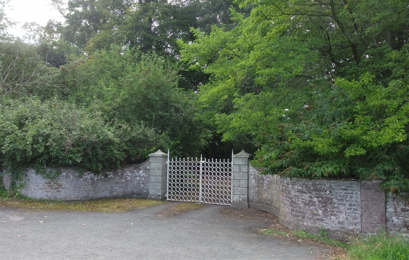
Probably mid C19. Thought to have been made in a forge at Glangrwyne on the N bank of the Usk, after 1830 by when the road is known to have been realigned from its original route which passed through the grounds of the house. Other pairs of similar gates are found in the locality. Plas Llangattwg, home of the Morgan family, dates from the Tudor period, it was largely rebuilt in the early C18 and substantially remodelled in the late C18.

Exterior

A pair of gates consisting of rows of wrought iron circles. The upper tier have open tops which are twisted. The ironwork is painted white. The gates are fixed to dressed stone piers with swept pyramidal copings. Masonry boundary walls extend from the piers.

Reasons for Listing

Listed as a fine pair of C19 wrought iron gates in a distinctive style and having group value with Plas Llangattwg.

External Links

External links are from the relevant listing authority and, where applicable, Wikidata. Wikidata IDs may be related buildings as well as this specific building. If you want to add or update a link, you will need to do so by editing the Wikidata entry.

Recommended Books

Other nearby listed buildings

  • II* 'Peach House' at Plas Llangattwg including attached former boiler-house
    Located in the kitchen gardens at Plas Llangattwg. The W end of the structure forms part of a long masonry wall which divides the formal gardens from the kitchen gardens.
  • II* Plas Llangattwg
    Located at the N end of the village, 0.15km from the church. The house is situated within oval-shaped gardens, the road curving round them to the SE. Ornate cast iron gates on the roadside lead to a
  • II Barn at Plas Llangattwg including pigsties
    Situated at the SW end of the grounds of Plas Llangatwg, and lining the street within Llangattock village.
  • II Beech View
    Located on the SW side of the main street in Llangattock, almost opposite Plas Llangattwg Barn and 0.3 km from the church.
  • II Churchyard Cross Base at Church of St Cattwg
    Located in the graveyard of St. Cattwg’s Church, alongside the path which runs along the S side of the church and just SW of the priest’s door.
  • II* Church of St Cattwg
    Located at the N end of the village, 0.6km from Crickhowell Bridge. In an oval churchyard with a lych gate to the SW.
  • II Horse Shoe Inn
    Located on the NE side of the main street in Llangattock village, opposite the turning to Park Drive.
  • II Village Farm
    Located in Llangattock village, immediately S of the Church. Bounded by a stone wall to the front with cast iron gate.

BritishListedBuildings.co.uk is an independent online resource and is not associated with any government department. All government data published here is used under licence. Please do not contact BritishListedBuildings.co.uk for any queries related to any individual listed building, planning permission related to listed buildings or the listing process itself.

British Listed Buildings is a Good Stuff website.