History in Structure

Beech View

A Grade II Listed Building in Llangattock, Powys

More Photos »
Approximate Location Map
Large Map »

Coordinates

Latitude: 51.853 / 51°51'10"N

Longitude: -3.146 / 3°8'45"W

OS Eastings: 321162

OS Northings: 217773

OS Grid: SO211177

Mapcode National: GBR F0.TG80

Mapcode Global: VH6CH.FP5D

Plus Code: 9C3RVV33+5H

Entry Name: Beech View

Listing Date: 21 October 1998

Last Amended: 21 October 1998

Grade: II

Source: Cadw

Source ID: 20729

Building Class: Domestic

ID on this website: 300020729

Location: Located on the SW side of the main street in Llangattock, almost opposite Plas Llangattwg Barn and 0.3 km from the church.

County: Powys

Community: Llangattock (Llangatwg)

Community: Llangattock

Built-Up Area: Llangattock

Traditional County: Brecknockshire

Tagged with: Architectural structure

Find accommodation in
Llangattock

History

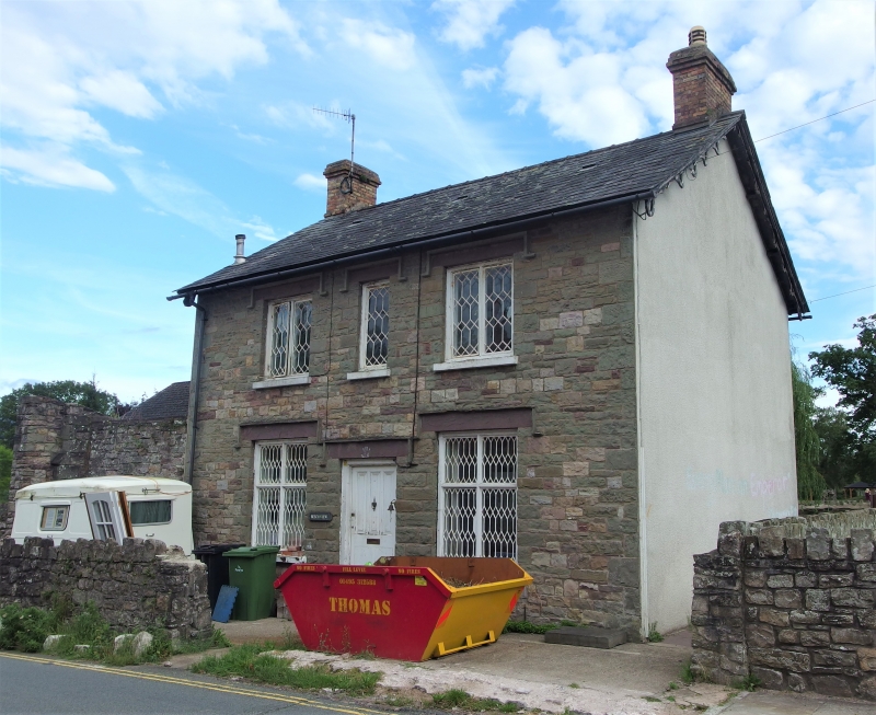
Late C19 house. Shown on the 1st edition Ordnance Survey of 1889.

Exterior

Three-window, 2-storey front of snecked stone under a slate roof with two brick end stacks. The front is symmetrical with Tudor-style stone lintels and hoodmoulds to the openings. Central panelled front door flanked by cross windows. The upper storey has a narrow central light flanked by 2-light casement wooden framed windows. The windows have distinctive iron-frame glazing in Tudor-style manner with hexagonal and lozenge patterns (more dense pattern to lower storey). The gable ends are rendered and have decorative barge boards. A low stone flat-roofed extension runs from the L. The rear is 3-window with small pane casement windows and stone lintels and sills.

Interior

No access to interior at time of inspection (August 1997)

Reasons for Listing

Listed as a good example of a C19 house which retains its original character, especially the distinctive glazing.

External Links

External links are from the relevant listing authority and, where applicable, Wikidata. Wikidata IDs may be related buildings as well as this specific building. If you want to add or update a link, you will need to do so by editing the Wikidata entry.

Recommended Books

Other nearby listed buildings

  • II Barn at Plas Llangattwg including pigsties
    Situated at the SW end of the grounds of Plas Llangatwg, and lining the street within Llangattock village.
  • II Horse Shoe Inn
    Located on the NE side of the main street in Llangattock village, opposite the turning to Park Drive.
  • II* Plas Llangattwg
    Located at the N end of the village, 0.15km from the church. The house is situated within oval-shaped gardens, the road curving round them to the SE. Ornate cast iron gates on the roadside lead to a
  • II Village Farm
    Located in Llangattock village, immediately S of the Church. Bounded by a stone wall to the front with cast iron gate.
  • II Old Six Bells
    Located in the centre of Llangattock village, 80m S of the Church, on the road which leads out to Ffawyddog.
  • II Churchyard Cross Base at Church of St Cattwg
    Located in the graveyard of St. Cattwg’s Church, alongside the path which runs along the S side of the church and just SW of the priest’s door.
  • II* 'Peach House' at Plas Llangattwg including attached former boiler-house
    Located in the kitchen gardens at Plas Llangattwg. The W end of the structure forms part of a long masonry wall which divides the formal gardens from the kitchen gardens.
  • II* Church of St Cattwg
    Located at the N end of the village, 0.6km from Crickhowell Bridge. In an oval churchyard with a lych gate to the SW.

BritishListedBuildings.co.uk is an independent online resource and is not associated with any government department. All government data published here is used under licence. Please do not contact BritishListedBuildings.co.uk for any queries related to any individual listed building, planning permission related to listed buildings or the listing process itself.

British Listed Buildings is a Good Stuff website.