History in Structure

Pont Ty'n-y-ddol

A Grade II Listed Building in Llangernyw, Conwy

More Photos »
Approximate Location Map
Large Map »

Coordinates

Latitude: 53.1744 / 53°10'27"N

Longitude: -3.6874 / 3°41'14"W

OS Eastings: 287313

OS Northings: 365471

OS Grid: SH873654

Mapcode National: GBR 68.44R5

Mapcode Global: WH65S.BGBS

Plus Code: 9C5R58F7+Q2

Entry Name: Pont Ty'n-y-ddol

Listing Date: 17 March 1999

Last Amended: 17 March 1999

Grade: II

Source: Cadw

Source ID: 21467

Building Class: Transport

ID on this website: 300021467

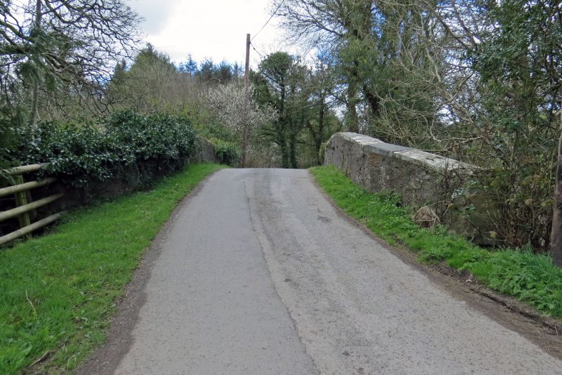
Location: The bridge carries the minor road, by-passed by the A548, between Llangernyw and Llanrwst over the Afon Gallen, 2km S of Llangernyw village centre.

County: Conwy

Town: Abergele

Community: Llangernyw

Community: Llangernyw

Traditional County: Denbighshire

Tagged with: Bridge Road bridge

Find accommodation in
Llangerniew

History

Probably late C18 or early C19.

Exterior

Road bridge, gently cambered, built of local stone rubble with single segmental arch springing from ground level capped with projecting regulating course. Spandrels rise to a projecting cambered string course at road level above which the parapets are coped with flush sandstone slabs, some recently renewed, linked with iron cramps. Wing walls terminate in square piers.

Reasons for Listing

Included as a good example of a wide single span bridge of a type erected in connection with improvements in rural communications in the late C18 and early C19.

External Links

External links are from the relevant listing authority and, where applicable, Wikidata. Wikidata IDs may be related buildings as well as this specific building. If you want to add or update a link, you will need to do so by editing the Wikidata entry.

Recommended Books

Other nearby listed buildings

  • II Milestone
    The milestone stands to the W side of the A548, approximately 2km SSW of Llangernyw village centre.
  • II Cow Byre and Mill at Plas yn Blaenau
    The byre and adjoining mill building form part of a row of farm buildings built into rising ground below the farmhouse. Byre united to adjacent byres to S by stone staircase rising from farmyard to
  • II Plas yn Blaenau
    On an elevated site at the end of a track 200m E of the minor road linking the B5384 to the A548, approximately 1km ENE of Pandy Tudur.
  • II Cow Byres and external stone stair at Plas yn Blaenau
    The byres stand in a row of farm buildings built into rising ground below the farmhouse. The buildings are parallel with and approximately 20m E of the farmhouse, with garden between.
  • II Farmyard ranges at Hendre Ddu
    Located SE of the farmhouse which is approximately 1.25 km S of Langernyw.
  • II Hendre Ddu
    Hendre Ddu stands to the N of a minor road 20m E of the A548, approximately 1.25km S of Llangernyw village centre.
  • II Cartshed, Barn, Byre and Shed at Hendre Ddu
    Situated SE of the farmhouse. Hendre Ddu stands to the N of a minor road 20m E of the A548, approximately 1.25km S of Llangernyw village centre.
  • II Pont Sylltu
    The bridge carries the minor road between Llangernyw and Gwytherin over the Afon Cledwen approximately 1.5km SE of Llangernyw village.

BritishListedBuildings.co.uk is an independent online resource and is not associated with any government department. All government data published here is used under licence. Please do not contact BritishListedBuildings.co.uk for any queries related to any individual listed building, planning permission related to listed buildings or the listing process itself.

British Listed Buildings is a Good Stuff website.