History in Structure

Milestone

A Grade II Listed Building in Llangernyw, Conwy

More Photos »
Approximate Location Map
Large Map »

Coordinates

Latitude: 53.1754 / 53°10'31"N

Longitude: -3.689 / 3°41'20"W

OS Eastings: 287207

OS Northings: 365586

OS Grid: SH872655

Mapcode National: GBR 68.3Y3M

Mapcode Global: WH65S.9GK0

Plus Code: 9C5R58G6+59

Entry Name: Milestone

Listing Date: 17 March 1999

Last Amended: 17 March 1999

Grade: II

Source: Cadw

Source ID: 21494

Building Class: Communications

ID on this website: 300021494

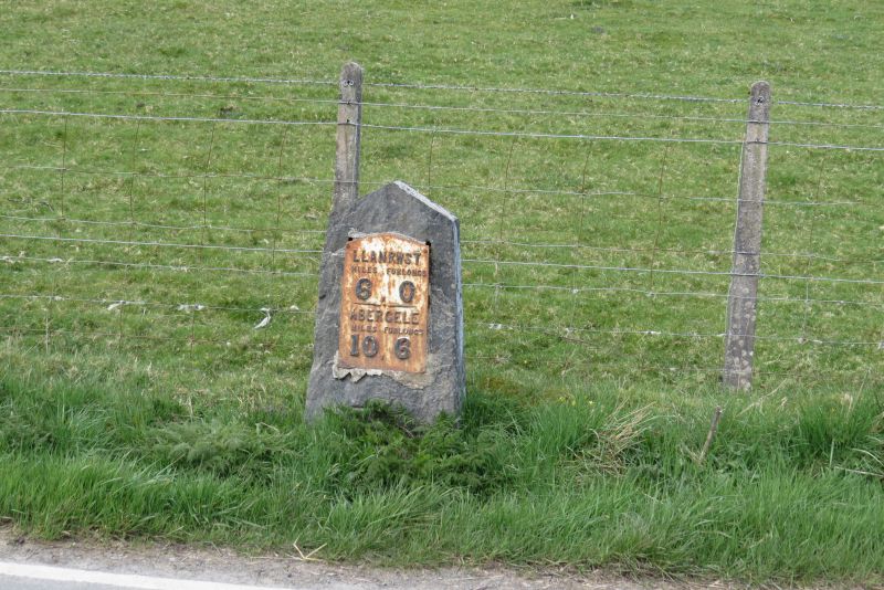
Location: The milestone stands to the W side of the A548, approximately 2km SSW of Llangernyw village centre.

County: Conwy

Town: Abergele

Community: Llangernyw

Community: Llangernyw

Traditional County: Denbighshire

Tagged with: Milestone

Find accommodation in
Llangerniew

History

The Act of Parliament for turnpiking the road from Abergele to Llanrwst, through Llangernyw was not passed until 22/23 Victoria (1858/9). Therefore this is a very late example of a milestone erected at a time when the maintenance of roads was passing from Turnpike Trusts to Highway Authorities.

Exterior

Mid C19 slate milestone with shallow triangular head and raking sides. Cast iron inset plate with raised lettering reading LLANRWST/ MILES FURLONGS/6 . 0/ ABERGELE/ MILES FURLONGS/10 . 6

Reasons for Listing

Included as a good and complete example of a mid C19 milestone retaining its cast iron plate.

External Links

External links are from the relevant listing authority and, where applicable, Wikidata. Wikidata IDs may be related buildings as well as this specific building. If you want to add or update a link, you will need to do so by editing the Wikidata entry.

Recommended Books

Other nearby listed buildings

  • II Pont Ty'n-y-ddol
    The bridge carries the minor road, by-passed by the A548, between Llangernyw and Llanrwst over the Afon Gallen, 2km S of Llangernyw village centre.
  • II Farmyard ranges at Hendre Ddu
    Located SE of the farmhouse which is approximately 1.25 km S of Langernyw.
  • II Hendre Ddu
    Hendre Ddu stands to the N of a minor road 20m E of the A548, approximately 1.25km S of Llangernyw village centre.
  • II Cartshed, Barn, Byre and Shed at Hendre Ddu
    Situated SE of the farmhouse. Hendre Ddu stands to the N of a minor road 20m E of the A548, approximately 1.25km S of Llangernyw village centre.
  • II Cow Byre and Mill at Plas yn Blaenau
    The byre and adjoining mill building form part of a row of farm buildings built into rising ground below the farmhouse. Byre united to adjacent byres to S by stone staircase rising from farmyard to
  • II Plas yn Blaenau
    On an elevated site at the end of a track 200m E of the minor road linking the B5384 to the A548, approximately 1km ENE of Pandy Tudur.
  • II Cow Byres and external stone stair at Plas yn Blaenau
    The byres stand in a row of farm buildings built into rising ground below the farmhouse. The buildings are parallel with and approximately 20m E of the farmhouse, with garden between.
  • I Hafodunos Hall
    About 1km WSW of Llangernyw.

BritishListedBuildings.co.uk is an independent online resource and is not associated with any government department. All government data published here is used under licence. Please do not contact BritishListedBuildings.co.uk for any queries related to any individual listed building, planning permission related to listed buildings or the listing process itself.

British Listed Buildings is a Good Stuff website.