Approximate Location Map
Large Map »
Latitude: 52.968 / 52°58'4"N
Longitude: -4.1607 / 4°9'38"W
OS Eastings: 254989
OS Northings: 343363
OS Grid: SH549433
Mapcode National: GBR 5N.K3RB
Mapcode Global: WH55D.1NZK
Plus Code: 9C4QXR9Q+5P
Entry Name: Ynys Pandy felin lechi
Listing Date: 30 March 1999
Last Amended: 30 March 1999
Grade: II*
Source: Cadw
Source ID: 21538
Building Class: Industrial
Also known as: Ynysypandy Slate-slab Mill
Gorseddau or Ynysypandy Slate Factory
ID on this website: 300021538
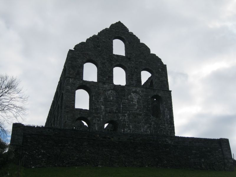
The Gorseddau Quarry was opened in the early-mid C19, and in 1853 was bought by Henry von Uster, who built the radial-type mill building some distance to the S in 1853-1857 at the cost of £50,000, together with the quarry village of Treforus, financed by the Bangor money-lender Richard Morris Griffith. This consisted of 36 semi-detached units in 3 streets, each property having a quarter of an acre (0.1ha) of land (only 18 were built). The lease of the mill was taken over in 1854 by Robert Gill of Mansfield and John Harris of Darlington, who proceeded with the development of Gorseddau on a grand scale becoming the Bangor and Portmadog Slate Co Ltd in 1857. At this stage it had up to 9 quarry terraces, served by 2ft (60.96cm) and 3ft (91.44cm) gauge railways. The complex also included Plas Llyn, the agent's house, and a 3ft (91.44cm) gauge horse tramway using 15ft (4.57m) long T-section wrought iron rails secured by cast iron chairs, excellently engineered to main line standards by James Brunlees, connecting the quarry to Portmadoc with only one reversing loop and no inclines. The mill itself is an outstanding building for this industry, the only multi-storey slate mill, perhaps influenced by contemporary foundry buildings and German precedents known to von Uster. It specialised in the preparing and finishing of slabs for floors, windows, dairies, agricultural feeding troughs, urinals, clock faces, sundials and similar items. The maximum annual output at its height in 1860 was 2148 tons (2182 tonnes), however this success was not sustained due to the inferior quality of the rock, and a year or two later the 200 men employed only produced 1500 tons (1524 tonnes). In 1867 it produced only 25 tons (25.4 tonnes), pushed by hand to Portmadoc, and finally went into liquidation in 1871, when it was bought by the Prince of Wales Quarry in Cwm Pennant. The mill was powered by water conducted into the building by launder and operating an enclosed overshot 26ft (7.86m) diameter wheel in the basement, from where drives were carried up to the working floors. Later the building provided a venue for local eisteddfodau until the roof was removed in c1906.
Plas Llyn is now only rubble, and the three terraces of dwellings at Treforus are now in ruin.
Built of uncoursed but carefully jointed stone rubble, originally with a slate roof which was removed in 1906. The building stands on an artificial platform held by retaining walls, and is of 3 storeys, developing into 4 at the W end. It is rectangular, 4 bays wide, and 9 bays long. Each bay has large semi-circular headed arches constructed of dressed voussoirs with keystones externally, the walls diminishing in thickness at each floor level to provide a seating for the Baltic pine floor joists, now missing. The E gable has a decorative feature around the top window. The original tramway is carried on a raised curving formation to the central opening on the S side, whilst the incoming water ran parallel and outside the S face of the building up to the entry point at the centre. Rubbish was carried out from the N side by a further tramway at 2ft (60.96cm) gauge and tipped to the NE of the mill.
The internal working arrangements of the mill are not known in detail, and it appears that there was some logical working progression down of material through the mill. A deep cross trench at the centre contained the leet driving the main drive water wheel, the water conducted in from the parallel channel on the S side.
Included at II* as a major monument of the Welsh slate winning industry, and one built to a unique design and on a magnificent scale - an ambitious design for industrial architecture.
Scheduled Ancient Monument No 11/2950/CN1609(GWY).
External links are from the relevant listing authority and, where applicable, Wikidata. Wikidata IDs may be related buildings as well as this specific building. If you want to add or update a link, you will need to do so by editing the Wikidata entry.


Other nearby listed buildings
