Approximate Location Map
Large Map »
Latitude: 52.9135 / 52°54'48"N
Longitude: -4.3525 / 4°21'9"W
OS Eastings: 241911
OS Northings: 337715
OS Grid: SH419377
Mapcode National: GBR 5D.NK62
Mapcode Global: WH44K.31N7
Plus Code: 9C4QWJ7W+CX
Entry Name: Former Stable at Penarth-fawr
Listing Date: 31 March 1999
Last Amended: 31 March 1999
Grade: II
Source: Cadw
Source ID: 21602
Building Class: Agriculture and Subsistence
ID on this website: 300021602
Location: The building stands to the N of Penarth-fawr, on the sharp bend of the road running N.
County: Gwynedd
Town: Criccieth
Community: Llanystumdwy
Community: Llanystumdwy
Locality: Penarth
Traditional County: Caernarfonshire
Tagged with: Stable
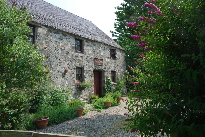
A large building, probably of C18 origins, remodelled in the C19, which formerly served as the stables to the post-medieval house of Penarth-fawr. Now craft workshops and a shop.
The building is constructed of local stone, with a slate roof. Two storeys, 3 bays, the third bay nearest the road probably a later extension and formerly containing a stable on the ground floor and stable-boy's accommodation above. Two boarded doors, and 4-pane windows to the upper bays, and three 6-pane single sash windows to the first floor. Stack on the gable end against the road, and a loft door at the E end, approached by a straight external stair, with an attached outbuilding. At the rear a long lean-to with cart house opening to the W end.
The interior has been refloored throughout in the C19 or early C20. It retains some timber stable partitions and slate feeding troughs. Loft over.
Included as a prominent building, a large example of a stable with accommodation, and an important part of the setting of the Grade I Penarth-fawr.
External links are from the relevant listing authority and, where applicable, Wikidata. Wikidata IDs may be related buildings as well as this specific building. If you want to add or update a link, you will need to do so by editing the Wikidata entry.


Other nearby listed buildings
