Approximate Location Map
Large Map »
Latitude: 51.6528 / 51°39'10"N
Longitude: -3.1906 / 3°11'26"W
OS Eastings: 317727
OS Northings: 195563
OS Grid: ST177955
Mapcode National: GBR HX.744V
Mapcode Global: VH6DF.NQ39
Plus Code: 9C3RMR35+4Q
Entry Name: Former Mynyddislwyn Urban District Council Offices
Listing Date: 31 March 1999
Last Amended: 31 March 1999
Grade: II
Source: Cadw
Source ID: 21620
Building Class: Institutional
ID on this website: 300021620
Location: In the centre of Pontllanfraith, facing the site of the former railway station and dismantled railway; standing on a walled and railed terrace a little above the roadway with steps to right and vehicu
County: Caerphilly
Community: Pontllanfraith (Pontllan-fraith)
Community: Pontllanfraith
Built-Up Area: Pontllan-fraith
Traditional County: Monmouthshire
Tagged with: Office building
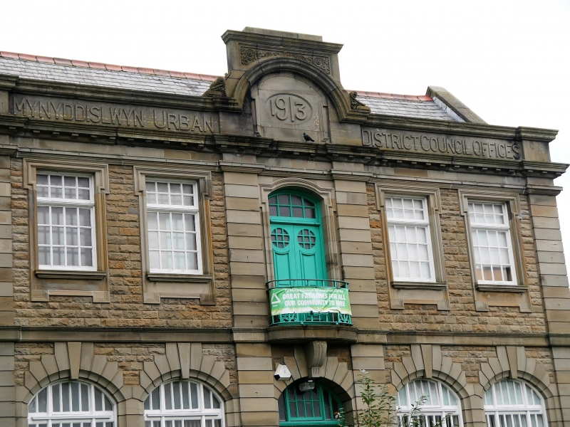
Built 1913. The building was extended in 1930s. Interior retains boards relating to Risca Urban District Council from 1894. Early photograph shows a cupola.
Purpose-built council offices in Edwardian Baroque style. Main block with parallel cross wings to rear, extended. Of rock-faced and dressed stone, roughcast to side, with Welsh slate roof and terracotta ridge tiles. Symmetrical 2 storey frontage. Windows are multipane with elaborate ashlar surrounds; moulded hoods, eared architraves and aprons to first floor and segmental-arched with prominent voussoirs, keystone and surrounds and shallow bracketed sills to ground floor. To first floor 2 windows either side of a central bay which is edged by pilasters and has an arched doorway leading onto a small curved balcony; the door has glazed roundels and multipane overlight. Above is a bracketed moulded parapet with inscription between cornice and coping, decoratively stepped up to centre to enclose a large datestone. A moulded stringcourse dividing the storeys extends across the frontage from the balcony which is supported by a deep bracket taking the place of the keystone to the high arched ground floor doorway this has very decoratively panelled recessed double doors and multipane overlight; dedication stones below. To side right similar mutipane window. Beyond later extension is a separate rendered block, possibly a generator house.
Interior has central corridor with rooms off either side; terrazzo floor and dado of green and cream decorative tiles in panels; basket arches to ceiling panels with decorative plaster corbels. Staircase to rear with wrought iron balusters. Large first floor council chamber across frontage with arch-braced roof and dado panelling, access to balcony.
Listed as unusually decorative purpose-built council offices from the time when coal-mining in this area was at its peak.
External links are from the relevant listing authority and, where applicable, Wikidata. Wikidata IDs may be related buildings as well as this specific building. If you want to add or update a link, you will need to do so by editing the Wikidata entry.


Other nearby listed buildings
