Approximate Location Map
Large Map »
Latitude: 53.0975 / 53°5'50"N
Longitude: -4.0684 / 4°4'6"W
OS Eastings: 261605
OS Northings: 357587
OS Grid: SH616575
Mapcode National: GBR 5S.8VLN
Mapcode Global: WH54V.GDXR
Plus Code: 9C5Q3WWJ+XM
Entry Name: Hafod Cottage
Listing Date: 28 May 1999
Last Amended: 28 May 1999
Grade: II
Source: Cadw
Source ID: 21857
Building Class: Domestic
ID on this website: 300021857
Location: Located on hillside on a rough track above the A 4086; low rubblestone wall in front of cottage.
County: Gwynedd
Town: Caernarfon
Community: Llanberis
Community: Llanberis
Locality: Gwastadnant
Traditional County: Caernarfonshire
Tagged with: Cottage
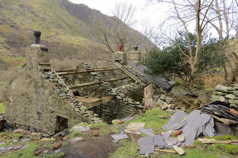
Built in the early C19 and shown on the 1838 Tithe Map, the cottage is one of several in the area which resulted from the dual economy of work in one of the local quarries and agriculture, the absence in this case of an associated cowhouse perhaps suggesting that here the former provided the main source of income. Abandoned and in poor condition at time of Survey.
Cottage. Single-storey 3-room plan with integral end stacks and ridge stack to left of centre. Roughly coursed rubblestone with extensive remains of lime plaster to front; slate roof. 4-paned sashes to either side of plank door to right with another 4-paned sash to left, all with slate cills; slate drips to stacks. Continuous catslide outshut to rear and lean-to extension set back to left.
Interior not accessible at time of Survey.
Included, notwithstanding poor condition, as a good example of an early C19 smallholder's/quarryman's cottage. Single storey vernacular cottages of this type form a particularly significant element in the dispersed settlement pattern associated with the dual economy, but well-preserved examples are becoming rare.
External links are from the relevant listing authority and, where applicable, Wikidata. Wikidata IDs may be related buildings as well as this specific building. If you want to add or update a link, you will need to do so by editing the Wikidata entry.


Other nearby listed buildings
