History in Structure

Talgae

A Grade II Listed Building in Llanberis, Gwynedd

More Photos »
Approximate Location Map
Large Map »

Coordinates

Latitude: 53.1015 / 53°6'5"N

Longitude: -4.0793 / 4°4'45"W

OS Eastings: 260888

OS Northings: 358051

OS Grid: SH608580

Mapcode National: GBR 5R.8RJQ

Mapcode Global: WH54V.99RP

Plus Code: 9C5Q4W2C+H7

Entry Name: Talgae

Listing Date: 28 May 1999

Last Amended: 28 May 1999

Grade: II

Source: Cadw

Source ID: 21834

Building Class: Domestic

ID on this website: 300021834

Location: Located behind a low rubblestone wall on the A 4086 at the south-eastern edge of Nant Peris.

County: Gwynedd

Town: Caernarfon

Community: Llanberis

Community: Llanberis

Locality: Nant Peris

Traditional County: Caernarfonshire

Tagged with: Architectural structure

Find accommodation in
Llanberis

History

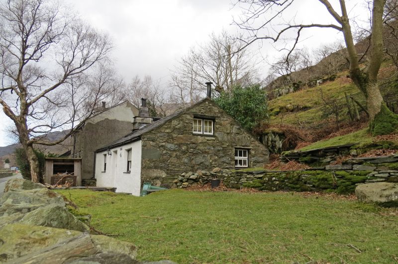
Early C19 smallholder's or quarry worker's cottage occupying roadside position; shown on the 1838 Tithe Map.

Exterior

Single-storey smallholder's or quarry worker's cottage. 2-room plan with loft over right room and heated room to left; catslide lean-to to rear. Roughly coursed rubblestone, limewashed to front; slate roof. 8-pane wide rectangular sashes with slate cills flank central C20 boarded door with glazed panel; small rooflight and stepped integral end stack with slate drips to left. 2-light casement lighting loft to right gable end.

Interior

Interior not accessible at time of survey.

Reasons for Listing

Listed as a substantially unaltered early C19 smallholder's or quarry worker's cottage, built in the local vernacular tradition.

External Links

External links are from the relevant listing authority and, where applicable, Wikidata. Wikidata IDs may be related buildings as well as this specific building. If you want to add or update a link, you will need to do so by editing the Wikidata entry.

Recommended Books

Other nearby listed buildings

  • II Milestone
    Located at Gwastadnant on the south side of the A 4086 at the south-eastern approach to Nant Peris.
  • II Pen-y-bryn
    Located within its own small field system in a prominent position on rising ground above the A 4086 at Nant Peris.
  • II Cwm-yr-Wrach
    Located in an isolated position within rubble-walled enclosure without vehicular access on hillside above the A 4086 at Nant Peris.
  • II Ffynnon Beris
    Located in the garden of Tyn-y-Ffynnon on the east side of a farm track running northwards from the A 4086 at Nant Peris.
  • II* Church of St Peris
    Located in the centre of Nant Peris at the western end of the Pass of Llanberis in a roughly rectangular-shaped churchyard with a stone lychgate dated 1929 on the northern side.
  • II Bryn Glas
    Situated in an isolated position without vehicular access on a rock outcrop on hillside in small rubblestone-walled enclosure above the A 4086 at Nant Peris.
  • II Capel Rehoboth
    Located in the centre of Nant Peris on the north side of the A 4086 with the former school immediately to the west and a row of C19 terraced houses directly opposite; small forecourt in front with low
  • II Hafod Cottage
    Located on hillside on a rough track above the A 4086; low rubblestone wall in front of cottage.

BritishListedBuildings.co.uk is an independent online resource and is not associated with any government department. All government data published here is used under licence. Please do not contact BritishListedBuildings.co.uk for any queries related to any individual listed building, planning permission related to listed buildings or the listing process itself.

British Listed Buildings is a Good Stuff website.