History in Structure

Milestone

A Grade II Listed Building in Llanberis, Gwynedd

More Photos »
Approximate Location Map
Large Map »

Coordinates

Latitude: 53.1002 / 53°6'0"N

Longitude: -4.0772 / 4°4'38"W

OS Eastings: 261019

OS Northings: 357906

OS Grid: SH610579

Mapcode National: GBR 5S.8L1T

Mapcode Global: WH54V.BBPN

Plus Code: 9C5Q4W2F+34

Entry Name: Milestone

Listing Date: 28 May 1999

Last Amended: 28 May 1999

Grade: II

Source: Cadw

Source ID: 21840

Building Class: Transport

ID on this website: 300021840

Location: Located at Gwastadnant on the south side of the A 4086 at the south-eastern approach to Nant Peris.

County: Gwynedd

Community: Llanberis

Community: Llanberis

Locality: Nant Peris

Traditional County: Caernarfonshire

Tagged with: Milestone

Find accommodation in
Llanberis

History

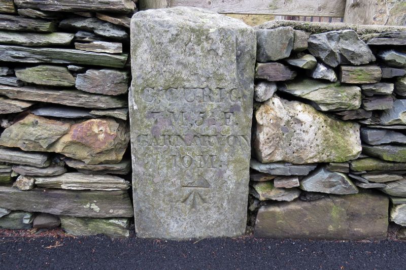
One of a series of milestones set up after the establishment of the turnpike road in the 1790s.

Exterior

Late C18 milestone relating to the turnpike road established in the 1790s. Roughly-shaped round-headed slate stone set in rubblestone roadside boundary wall. Inscribed "C. CURIG/ 7 M. 5 1/2 F./ CARNARVON/ 10 M." Ordnance Survey bench-mark symbol beneath.

Reasons for Listing

Included for its special historic interest as a turnpike road milestone, a well-preserved example of a characteristic local type.

External Links

External links are from the relevant listing authority and, where applicable, Wikidata. Wikidata IDs may be related buildings as well as this specific building. If you want to add or update a link, you will need to do so by editing the Wikidata entry.

Recommended Books

Other nearby listed buildings

  • II Talgae
    Located behind a low rubblestone wall on the A 4086 at the south-eastern edge of Nant Peris.
  • II Pen-y-bryn
    Located within its own small field system in a prominent position on rising ground above the A 4086 at Nant Peris.
  • II Cwm-yr-Wrach
    Located in an isolated position within rubble-walled enclosure without vehicular access on hillside above the A 4086 at Nant Peris.
  • II Ffynnon Beris
    Located in the garden of Tyn-y-Ffynnon on the east side of a farm track running northwards from the A 4086 at Nant Peris.
  • II* Church of St Peris
    Located in the centre of Nant Peris at the western end of the Pass of Llanberis in a roughly rectangular-shaped churchyard with a stone lychgate dated 1929 on the northern side.
  • II Bryn Glas
    Situated in an isolated position without vehicular access on a rock outcrop on hillside in small rubblestone-walled enclosure above the A 4086 at Nant Peris.
  • II Hafod Cottage
    Located on hillside on a rough track above the A 4086; low rubblestone wall in front of cottage.
  • II Capel Rehoboth
    Located in the centre of Nant Peris on the north side of the A 4086 with the former school immediately to the west and a row of C19 terraced houses directly opposite; small forecourt in front with low

BritishListedBuildings.co.uk is an independent online resource and is not associated with any government department. All government data published here is used under licence. Please do not contact BritishListedBuildings.co.uk for any queries related to any individual listed building, planning permission related to listed buildings or the listing process itself.

British Listed Buildings is a Good Stuff website.