History in Structure

Telephone Call-box outside Pioneer Hotel

A Grade II Listed Building in Cwmfelinfach, Caerphilly

More Photos »
Approximate Location Map
Large Map »

Coordinates

Latitude: 51.6186 / 51°37'6"N

Longitude: -3.1786 / 3°10'42"W

OS Eastings: 318499

OS Northings: 191742

OS Grid: ST184917

Mapcode National: GBR HY.975R

Mapcode Global: VH6DM.VLG1

Plus Code: 9C3RJR9C+CH

Entry Name: Telephone Call-box outside Pioneer Hotel

Listing Date: 16 September 1999

Last Amended: 16 September 1999

Grade: II

Source: Cadw

Source ID: 22320

Building Class: Communications

ID on this website: 300022320

Location: In front of the Pioneer Hotel to left side.

County: Caerphilly

Community: Ynysddu (Ynys-ddu)

Community: Ynysddu

Locality: Cwmfelin-fach

Built-Up Area: Cwmfelinfach

Traditional County: Monmouthshire

Tagged with: Hotel

Find accommodation in
Mynyddislwyn

History

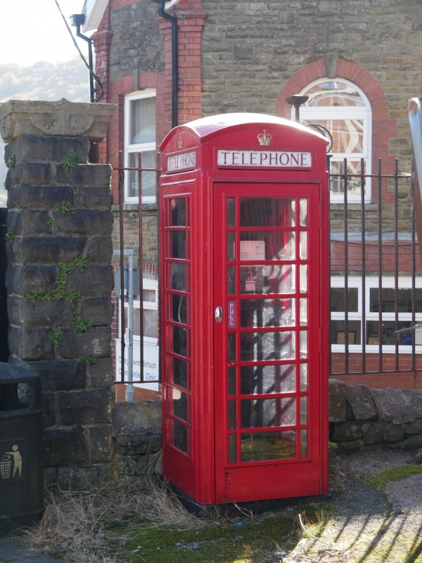
K6-type square, red kiosk of cast-iron construction to the standard design of Giles Gilbert Scott, architect of London. Design introduced by GPO in 1936.

Exterior

Domed roof with 4 lunettes with red lettered opals and ventilation slits. Raised surrounds to sides and door with margin bars to horizontal glazing. Blank rear, moulded plinth; modernised telephone equipment.

Reasons for Listing

Included for group value with the hotel.

External Links

External links are from the relevant listing authority and, where applicable, Wikidata. Wikidata IDs may be related buildings as well as this specific building. If you want to add or update a link, you will need to do so by editing the Wikidata entry.

Recommended Books

Other nearby listed buildings

  • II The Pioneer Hotel
    Right in the centre of Cwmfelin-fach at the junction of five roads.
  • II Capel y Babell
    On the S boundary of Cwmfelin-fach and a short way N of the Sirhowy River, in a maintained open space, a walled graveyard adjoining to E.
  • II Islwyn Monument in Babell Cemetery
    Close to the front wall of Babell chapel within the walled cemetery.
  • II Glebe Farm
    On the S flank of Mynyddislwyn, off the E side of the lane leading S to Cwmfelin-fach, and reached by a farm track across fields.
  • II Brynysgawen and attached farm range
    On the W hillside of the Sirhowy Valley due W of Ynysddu, reached by the mountain road from Gelli-groes, and along a farm track.
  • II Stable block at Brynysgawen
    On the opposite side of the farmyard to the farmhouse and barn range.
  • II Ton-eithin
    Just E of the crest of Mynyddislwyn, SE of the church, on the upper slope of Nant Hafod-Tudur, reached by a long farm track.

BritishListedBuildings.co.uk is an independent online resource and is not associated with any government department. All government data published here is used under licence. Please do not contact BritishListedBuildings.co.uk for any queries related to any individual listed building, planning permission related to listed buildings or the listing process itself.

British Listed Buildings is a Good Stuff website.