Approximate Location Map
Large Map »
Latitude: 53.0749 / 53°4'29"N
Longitude: -4.2434 / 4°14'36"W
OS Eastings: 249807
OS Northings: 355429
OS Grid: SH498554
Mapcode National: GBR 5K.B7PG
Mapcode Global: WH43M.SZJ2
Plus Code: 9C5Q3QF4+XJ
Entry Name: Ty Newydd
Listing Date: 30 September 1999
Last Amended: 30 September 1999
Grade: II
Source: Cadw
Source ID: 22413
Building Class: Domestic
ID on this website: 300022413
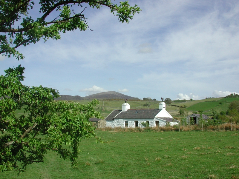
Location: Situated in marshy low-lying small-field landscape, set back from minor road running north-east from Carmel towards Rhosgadfan.
County: Gwynedd
Town: Caernarfon
Community: Llandwrog
Community: Llandwrog
Locality: Carmel
Traditional County: Caernarfonshire
Tagged with: Architectural structure
Shown on the 1840 Tithe Map, the cottage is likely to have been built in the early C19 as a smallholder's cottage but its occupants are likely to have supplemented their income from subsistence farming by working in one of the nearby slate quarries. Modest C20 extensions to gable ends and rear.
Single-storey 2-room plan, aligned roughly north-east to south-west. Painted roughly coursed rubblestone; slate roof. Front has C20 windows in original openings flanking slightly offset boarded door with small rooflight directly above; integral end stacks with slate drips, left more substantial. Slightly set-down gabled addition to left gable end and lean-to addition to right. Rear has catslide, probably C19, lean-to on left and C20 lean-to on right; flush rooflight with vertical bar in main roof slope between.
Interior not accessible at time of Survey.
Included, notwithstanding some modest C20 extension, as an essentially well-preserved early C19 cottage, built in the local vernacular tradition characteristic of the area, and illustrating the importance of the dual agricultural and industrial economy of the period. The building is a typical feature in the landscape of small fields and scattered cottages, characteristic of the upland settlement pattern associated with the development of quarrying in this region.
External links are from the relevant listing authority and, where applicable, Wikidata. Wikidata IDs may be related buildings as well as this specific building. If you want to add or update a link, you will need to do so by editing the Wikidata entry.


Other nearby listed buildings
