Approximate Location Map
Large Map »
Latitude: 51.6876 / 51°41'15"N
Longitude: -3.125 / 3°7'29"W
OS Eastings: 322327
OS Northings: 199363
OS Grid: ST223993
Mapcode National: GBR J0.4W36
Mapcode Global: VH6D8.SV94
Plus Code: 9C3RMVQG+32
Entry Name: Swffryd-ganol including front garden wall
Listing Date: 26 November 1999
Last Amended: 26 November 1999
Grade: II
Source: Cadw
Source ID: 22673
Building Class: Domestic
ID on this website: 300022673
Location: Situated on hillside, approximately 0.75 km NE of Sofrydd, reached via farm track at end of Farm Road.
County: Blaenau Gwent
Community: Llanhilleth (Llanhiledd)
Community: Llanhilleth
Locality: Sofrydd
Traditional County: Monmouthshire
Tagged with: Farmhouse
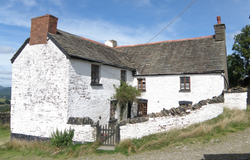
C17 farmhouse, much remodelled in early C19. Plan before remodelling possibly had cross-passage entry and downslope byre. The S-facing wing is probably pre-C19 in origin, but much remodelled in late C19 when roof of wing was raised to present shallow pitch, and all windows were replaced with casements. Shown in present form on 1843 Tithe Map, when owned by Sir Benjamin Hall, and occupied by Thomas David (56 acres (22.6 hectares)).
Rubble built two storey farmhouse of L-plan, the angle enclosed by drystone rubble wall to small front (S) garden. Roof of local stone tiles, currently being reinstated. Main section of farmhouse aligned E-W, with projecting two-bay range to left. Broad rendered chimney stack to W end, stone stack to E gable; red brick stack to S gable. S-facing side of garden elevation of two bays: two-light four-pane casements above four-pane windows: cambered stone voussoired heads, stone sills. E facing elevation also of two bays: upper window are two-light 12-pane casements set under eaves. Similar window to ground floor centre with brick head: straight joints show that this was originally a door. Door to extreme right, cambered stone voussoired head. W elevation of wing has two ground floor windows with collapsed lintels. To left against gable end of main range is single storey lean-to, of rubble. Vague joints visible to lower part of gable wall, possibly associated with a lost lower range (possibly a byre). Rear (N) elevation has small window to right and broad outshut to left under catslide roof.
Living room to W end of main range has massive fireplace opening with large iron grate. Stone flags to floor. To right of fireplace is chimney stair with timber treads: door to stair has segmental chamfered timber frame, early C17. Two stop-chamfered beams. Parlour to E end has ceiling removed: entered via planked door. S room in wing has C19 fireplace; ceiling removed. Roof structure of main range looks C19; simple collar trusses.
Listed as an unspoilt upland farmhouse, with early C17 origins, also retaining its stone-tiled roof and original interior detail.
External links are from the relevant listing authority and, where applicable, Wikidata. Wikidata IDs may be related buildings as well as this specific building. If you want to add or update a link, you will need to do so by editing the Wikidata entry.


Other nearby listed buildings
