History in Structure

Milestone on N side of A4230

A Grade II Listed Building in Coedffranc (Coed-ffranc), Neath Port Talbot

More Photos »
Approximate Location Map
Large Map »

Coordinates

Latitude: 51.6606 / 51°39'38"N

Longitude: -3.8516 / 3°51'5"W

OS Eastings: 272028

OS Northings: 197384

OS Grid: SS720973

Mapcode National: GBR H0.6RXK

Mapcode Global: VH4K5.6J69

Plus Code: 9C3RM46X+79

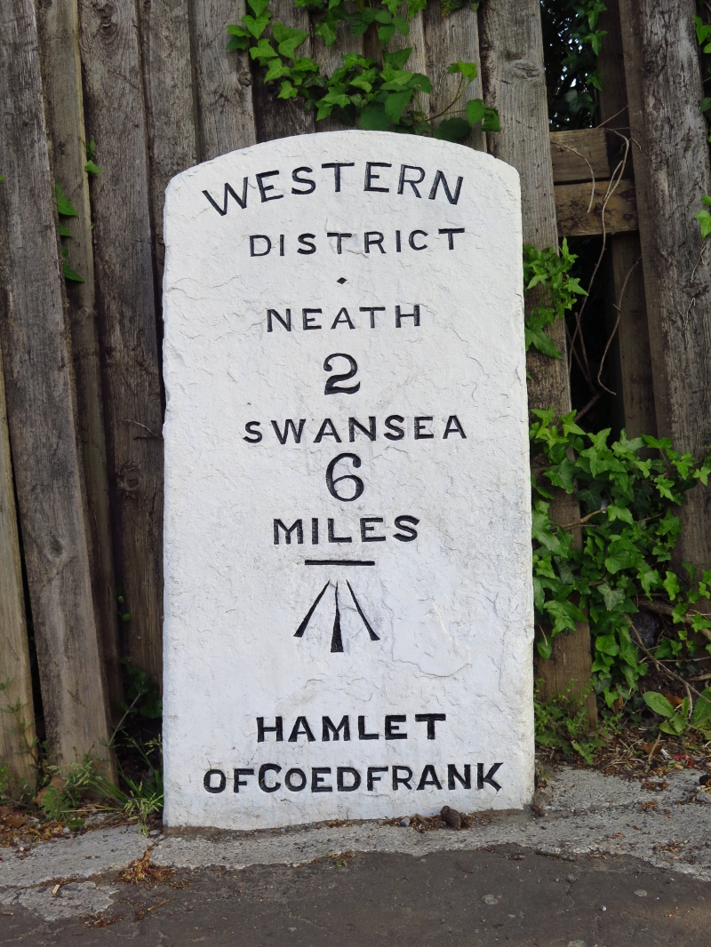
Entry Name: Milestone on N side of A4230

Listing Date: 29 March 2000

Last Amended: 29 March 2000

Grade: II

Source: Cadw

Source ID: 23071

Building Class: Transport

ID on this website: 300023071

Location: Set back on the N side of New Road S of its junction with Railway Terrace/Brookville Drive and on the N side of a railway overbridge.

County: Neath Port Talbot

Community: Coedffranc (Coed-ffranc)

Community: Coedffranc

Locality: Skewen

Built-Up Area: Neath

Traditional County: Glamorgan

Tagged with: Milestone

Find accommodation in
Llandarcy

History

Probably erected in the mid C19 and first shown on the 1877 Ordnance Survey.

Exterior

A dressed milestone with segmental top and engraved letters reading: WESTERN/DISTRICT/NEATH/2/SWANSEA/6/MILES/HAMLET/OF COEDFRANK

Reasons for Listing

Listed for its historic interest as illustrative of transport history in the area.

External Links

External links are from the relevant listing authority and, where applicable, Wikidata. Wikidata IDs may be related buildings as well as this specific building. If you want to add or update a link, you will need to do so by editing the Wikidata entry.

Recommended Books

Other nearby listed buildings

  • II New Road Overbridge
    In Skewen, on New Road, near its junction with Dynevor Way and Railway Terrace/Brookville Drive.
  • II Hermon Chapel
    Set back behind a railed forecourt facing N to an unmetalled road on the W side of Winifred Road.
  • II Bethania Chapel
    Set back from and above the road behind a grassed forecourt with railings to the street.
  • II New Road Methodist Church
    Facing New Road (A4230) towards the W side of Skewen village.
  • II Tabernacle Chapel Hall
    Situated directly opposite Tabernacle Chapel.
  • II Tabernacle Chapel
    Facing the street running from the S side of the A4230 through the village.
  • II Horeb Chapel
    Centrally located in the village facing the main A4230; Bethlehem Road to rear.
  • II Gorphwysfa Chapel
    Set back from the street behind forecourt gates and railings W of the junction with Drymau Road.

BritishListedBuildings.co.uk is an independent online resource and is not associated with any government department. All government data published here is used under licence. Please do not contact BritishListedBuildings.co.uk for any queries related to any individual listed building, planning permission related to listed buildings or the listing process itself.

British Listed Buildings is a Good Stuff website.