Approximate Location Map
Large Map »
Latitude: 51.5726 / 51°34'21"N
Longitude: -3.7565 / 3°45'23"W
OS Eastings: 278370
OS Northings: 187431
OS Grid: SS783874
Mapcode National: GBR H4.D5V1
Mapcode Global: VH5H1.TQZT
Plus Code: 9C3RH6FV+2C
Entry Name: Vestry at Beulah Chapel
Listing Date: 25 April 2000
Last Amended: 25 April 2000
Grade: II
Source: Cadw
Source ID: 23282
Building Class: Religious, Ritual and Funerary
ID on this website: 300023282
Location: Located in Tollgate Park immediately N of Beulah Chapel and almost adjoining.
County: Neath Port Talbot
Town: Port Talbot
Community: Margam
Community: Margam
Locality: Tollgate Park
Built-Up Area: Port Talbot
Traditional County: Glamorgan
Tagged with: Architectural structure
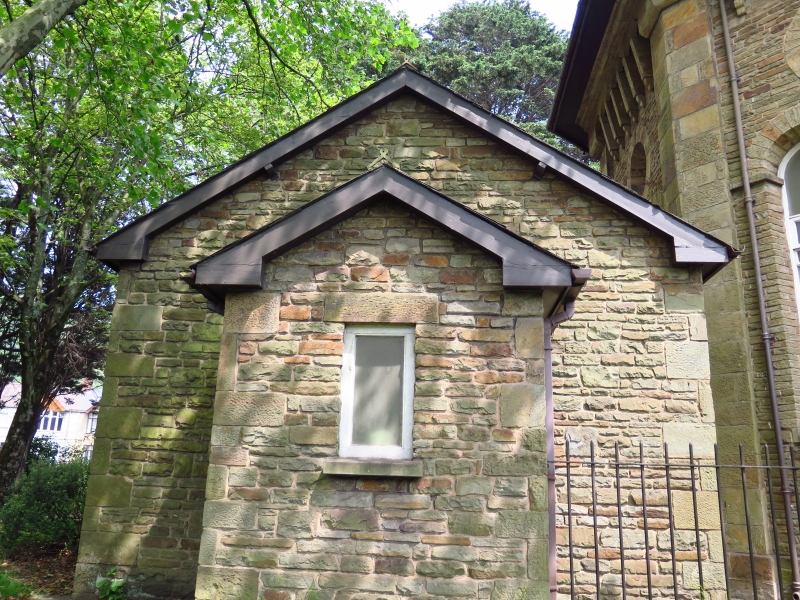
The vestry is contemporary with Beulah Chapel. Formerly located in the village of Groes, designed by the architect Edward Haycock in 1838. Shown in old photographs of Groes adjacent to the chapel. The village was affected by the M4 motorway in 1974 and the chapel, vestry, and gates were taken down and subsequently rebuilt in Tollgate Park in 1976.
Single-storey 3-window range orientated E-W. Constructed of rubble stone with quoins under a slate roof. Stone end stack to E. Gabled porch to W with planked door to S side under a stone lintel, and single light window to W. Three-light windows to each side with heavy stone lintels and stone sills. Wooden windows with horizontal glazing bar and iron opening handles.
Entrance vestibule with planked doors. The interior is open with a stage at the E end. The fireplace is blocked. The rafters are partially visible beneath the ceiling.
Listed for group value with Beulah Chapel and the gates and railings.
External links are from the relevant listing authority and, where applicable, Wikidata. Wikidata IDs may be related buildings as well as this specific building. If you want to add or update a link, you will need to do so by editing the Wikidata entry.


Other nearby listed buildings
