Approximate Location Map
Large Map »
Latitude: 51.5826 / 51°34'57"N
Longitude: -3.7672 / 3°46'2"W
OS Eastings: 277650
OS Northings: 188564
OS Grid: SS776885
Mapcode National: GBR H4.CH40
Mapcode Global: VH5H1.NH83
Plus Code: 9C3RH6MM+24
Entry Name: Milepost
Listing Date: 31 January 2000
Last Amended: 31 January 2000
Grade: II
Source: Cadw
Source ID: 22808
Building Class: Transport
ID on this website: 300022808
Location: Located on the pavement near the junction with Heol yr Orsedd.
County: Neath Port Talbot
Town: Port Talbot
Community: Tai-bach
Community: Tai-Bach
Locality: Tai Bach
Built-Up Area: Port Talbot
Traditional County: Glamorgan
Tagged with: Milestone
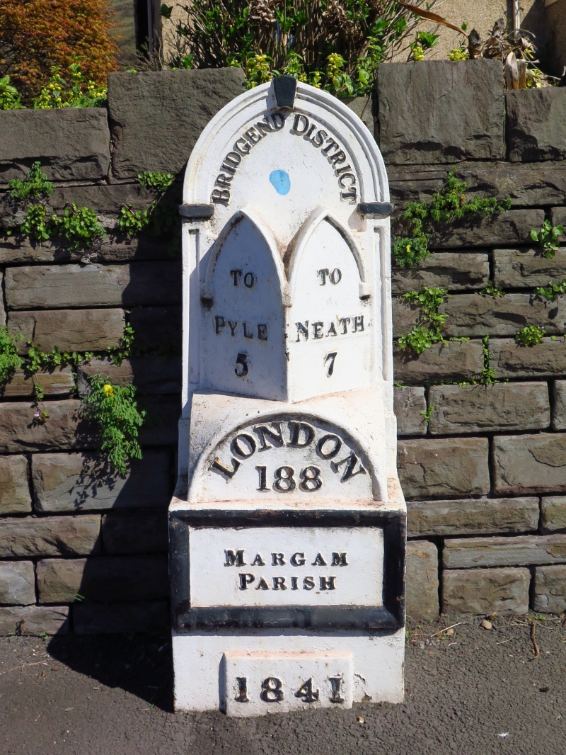
One of a group of mileposts in Gothic style, associated with the turnpiking of the Swansea to London road (now A48).
Ornate cast iron milepost, painted white with black lettering and detail. Square base supporting a rear upright with pointed arched head with mouldings, imposts and keystone. In front, the base supports a low domed section with round-headed front face, above which are 2 tall faces with pointed arched heads each set at an angle of 45 degrees. The arches have raised mouldings.
Underneath the rear arch, the milepost reads 'Bridgend District'. The angled faces point in opposite directions, one reading 'To Pyle 5' and the other 'To Neath 7'. Underneath the round arch is the lettering 'London 188'. The square base has a raised border within which 'Margam Parish' is written in relief. A raised tablet at the bottom (unpainted) reads '1841'.
Listed for its historic interest as a characteristic feature of turnpike roads, and in an unusually ornate Gothic style. Group value with other mileposts on this section of the A48.
External links are from the relevant listing authority and, where applicable, Wikidata. Wikidata IDs may be related buildings as well as this specific building. If you want to add or update a link, you will need to do so by editing the Wikidata entry.


Other nearby listed buildings
