Approximate Location Map
Large Map »
Latitude: 53.1336 / 53°8'1"N
Longitude: -4.0353 / 4°2'7"W
OS Eastings: 263932
OS Northings: 361545
OS Grid: SH639615
Mapcode National: GBR 5T.6Q6N
Mapcode Global: WH54N.ZHLJ
Plus Code: 9C5Q4XM7+FV
Entry Name: Pentre Farmhouse
Listing Date: 24 May 2000
Last Amended: 24 May 2000
Grade: II
Source: Cadw
Source ID: 23358
Building Class: Domestic
ID on this website: 300023358
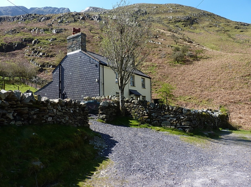
Location: Remote roadside position on minor valley road running parallel with the A5 along the Ogwen valley; low rubblestone wall in front of farmhouse with stone-on-edge coping and iron gate and steps to centr
County: Gwynedd
Town: Bangor
Community: Llandygai (Llandygái)
Community: Llandygai
Locality: Nant Ffrancon
Traditional County: Caernarfonshire
Tagged with: Farmhouse
Not shown on the 1839 Tithe Map, the farmhouse was probably built c1850 as part of the expansion of farming in the remote Ogwen valley at this period, much of which sponsored by the Penrhyn Estate. The road on which the farmhouse is situated is the so-called "old road", an improvement by the Estate in 1790-1 of what Thomas Pennant had described as "the most dreadfull horsepath in Wales". Several other farms are sited on this road, which was effectively superseded as the main through route along the Ogwen valley by the building of the turnpike road on its eastern side in 1802.
2-storey, roughly symmetrical 3-bay front. Rendered rubblestone, painted to front; slate roof with coped verges. Three 6-paned sashes with slate cills on first floor (probably original) and 2 on ground floor, one to each side of slightly offset entrance with C20 boarded door under C20 lean-to porch; tall integral end stacks. Lean-to to rear.
Interior not accessible at time of Survey.
Included as a well-preserved mid-C19 farmhouse in the late Georgian tradition with contemporary farmbuildings, illustrative of the colonisation of marginal agricultural land at this period and forming a typically distinctive component of this rugged upland landscape.
External links are from the relevant listing authority and, where applicable, Wikidata. Wikidata IDs may be related buildings as well as this specific building. If you want to add or update a link, you will need to do so by editing the Wikidata entry.


Other nearby listed buildings
