Latitude: 51.8056 / 51°48'20"N
Longitude: -3.1295 / 3°7'46"W
OS Eastings: 322215
OS Northings: 212484
OS Grid: SO222124
Mapcode National: GBR F1.XDC8
Mapcode Global: VH6CP.PWW7
Plus Code: 9C3RRV4C+65
Entry Name: Limekilns at Llanelly Limeworks
Listing Date: 27 July 2000
Last Amended: 27 July 2000
Grade: II
Source: Cadw
Source ID: 23822
Building Class: Industrial
ID on this website: 300023822
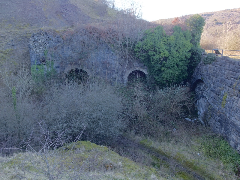
Location: Former quarry located approximately 1 km NE of Darrenfelen, alongside by-road between Clydach and Darrenfelen. Quarry is entered via tunnels underneath small railway viaduct, and kiln is located on th
County: Monmouthshire
Community: Llanelly (Llanelli)
Community: Llanelly
Locality: Darrenfelen
Traditional County: Brecknockshire
Tagged with: Lime kiln
Probably built in 1863 or soon after, when John Jayne, ironmaster of the Clydach Ironworks leased the site from the Duke of Beaufort, assigning it to the New Clydach Sheet and Iron Co. Ltd. in the same year. The quarry produced limestone for fluxing at the ironworks, and also burnt lime for mortar and agricultural purposes, as well as roadstone. The Merthyr, Tredegar and Abergavenny Railway (1862) ran immediately adjacent, and by 1884, Lewis Daniel and Son were trading in limestone from a railway siding. In c. 1910, the quarry was purchased from F.C. Lowe of Abergavenny by the Clydach and Abergavenny Lime and Stone Company, which employed 29 men in 1913. Taken over by Robert C. Laird of Malvern in 1930, closing c. 1935. Reopened 1950-51 to produce agricultural crushed lime, processed at the Clydach Limeworks. Finally closed by 1963
Large rectangular kiln with battered walls. Squared limestone rubble walls. Pair of round-arched drawing-arches, the arch-rings formed of three courses of yellow brick headers. Left arch much overgrown: right arch has partly-collapsed vault.
Listed as a large well preserved late C19 block of limekilns, a prominent survival of the important industrial landscape of the Clydach Gorge.
External links are from the relevant listing authority and, where applicable, Wikidata. Wikidata IDs may be related buildings as well as this specific building. If you want to add or update a link, you will need to do so by editing the Wikidata entry.


Other nearby listed buildings