Approximate Location Map
Large Map »
Latitude: 51.8104 / 51°48'37"N
Longitude: -3.1243 / 3°7'27"W
OS Eastings: 322585
OS Northings: 213021
OS Grid: SO225130
Mapcode National: GBR F1.X1NG
Mapcode Global: VH6CP.SRNH
Plus Code: 9C3RRV6G+57
Entry Name: Oak House
Listing Date: 27 July 2000
Last Amended: 30 July 2001
Grade: II
Source: Cadw
Source ID: 23811
Building Class: Domestic
ID on this website: 300023811
Location: Located on the E side of Cheltenham village, at junction with Rhonos Road.
County: Monmouthshire
Community: Llanelly (Llanelli)
Community: Llanelly
Locality: Cheltenham
Built-Up Area: Clydach
Traditional County: Brecknockshire
Tagged with: House
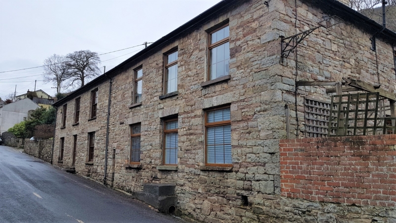
Early C19, shown on 1847 Tithe Map as owned by the Duke of Beaufort, and occupied by William Hiley and others. The house and surrounding houses are collectively named on the apportionment as cottages, but the unusual depth and scale of the house may suggest original commercial functions in connection with the Clydach Ironworks. The style suggests a date of c1840, built alongside the turnpike road of 1812-13 that now forms Main Road. The building was once a public house with attached dwelling. The right-hand section is, perhaps, a little later in date.
Two-storey building with 6 window front. Rubble (left hand section whitewashed). Very broad hipped slate roof (rear slope artificial slates). Tall brick chimney to each end. Left hand section of 3 windows with flat heads with cut stone voussoirs, and shallow stone sills. Central doorway to this section (once broader) with boarded door. Windows in this section are 16-pane hornless sashes (but ground floor window to R is covered over).
Right hand section of 3 windows, also with flat heads and stone voussoirs, but generally deeper sills. Modern glazing; former doorway to centre on ground floor. Right hand return with doorway, and extension towards rear. Rear of property (formerly built into steep bank) under renovation at time of inspection.
Right hand section largely modernised, but retains 6-panelled doors. Left hand section semi-derelict. Two rooms with wooden stairs to rear, partly removed partition to R with 6-panelled door, C19 fireplace in room to L.
Listed, despite condition, as unusually substantial early C19 building retaining its overall character.
External links are from the relevant listing authority and, where applicable, Wikidata. Wikidata IDs may be related buildings as well as this specific building. If you want to add or update a link, you will need to do so by editing the Wikidata entry.


Other nearby listed buildings
