Latitude: 53.2811 / 53°16'51"N
Longitude: -3.2663 / 3°15'58"W
OS Eastings: 315670
OS Northings: 376760
OS Grid: SJ156767
Mapcode National: GBR 5ZMH.NJ
Mapcode Global: WH76J.SSTJ
Plus Code: 9C5R7PJM+CF
Entry Name: Limekiln
Listing Date: 25 May 2001
Last Amended: 25 May 2001
Grade: II
Source: Cadw
Source ID: 25251
Building Class: Industrial
ID on this website: 300025251
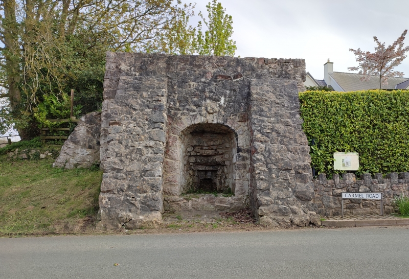
Location: In a prominent position fronting the road between Carmel and Gorsedd. On the S side of the road and at a junction with a lane running N.
County: Flintshire
Town: Holywell
Community: Whitford (Chwitffordd)
Community: Whitford
Locality: Gorsedd
Built-Up Area: Gorsedd
Traditional County: Flintshire
Tagged with: Lime kiln
A small enclosure is shown in this location on the Ordnance Survey of 1871, by which time the kiln had presumably gone out of use. The quarries for the kiln are said to be in the field immediately behind. It is likely to have produced lime for agricultural purposes.
Small single limekiln constructed of rubble stone with quoins, standing full-height. Short draw-hole tunnel with tall narrow segmental-headed arch of stone voussoirs. Stone soffit to draw-hole tunnel which curves down towards the rear. Cast iron lintel above draw-hole, the jambs of which are partly missing, and with brick and stone to the head. The arch is flanked by full-height raked buttresses, close to the angles. Further buttress or wall adjoining E side of kiln, the W side plain. No access to top of limekiln.
Listed as a well-preserved limekiln in its quarry context, in a highly visible position.
External links are from the relevant listing authority and, where applicable, Wikidata. Wikidata IDs may be related buildings as well as this specific building. If you want to add or update a link, you will need to do so by editing the Wikidata entry.


Other nearby listed buildings