History in Structure

Milepost

A Grade II Listed Building in Heath, Cardiff

More Photos »
Approximate Location Map
Large Map »

Coordinates

Latitude: 51.5058 / 51°30'20"N

Longitude: -3.1986 / 3°11'54"W

OS Eastings: 316908

OS Northings: 179221

OS Grid: ST169792

Mapcode National: GBR KCB.R5

Mapcode Global: VH6F6.HFW0

Plus Code: 9C3RGR42+8H

Entry Name: Milepost

Listing Date: 18 July 2001

Last Amended: 18 July 2001

Grade: II

Source: Cadw

Source ID: 25523

Building Class: Transport

ID on this website: 300025523

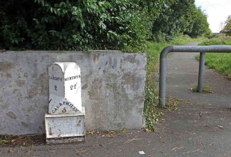
Location: Located on the NE side of Gabalfa Interchange, on a slip road which joins Eastern Avenue (A48). Against a concrete wall which fronts an open space.

County: Cardiff

Town: Cardiff

Community: Heath (Y Mynydd Bychan)

Community: Heath

Locality: Gabalfa Interchange

Built-Up Area: Cardiff

Traditional County: Glamorgan

Tagged with: Milestone

Find accommodation in
Cardiff

History

C19 milepost, shown on the Ordnance Survey of 1880, which was located at the junction of two important routes out of Cardiff, Merthyr Road and Caerphilly Road. The arrangement of roads, with the construction of Gabalfa interchange, is much altered and the milepost is probably not in its original position.

Exterior

Cast iron milepost of triangular cross-section on a short square base. The 2 faces at 45 degrees have round-arched tops and lettering in relief. That to the L reads 'Cardiff 2', that to the R, 'Merthyr 22'. These faces are splayed at the base, and a triangle facing forward reads 'Caerphilly 5'. The square base has a recessed panel to the front which may have had an inscription.

Reasons for Listing

Listed as a rare survival of a milepost at the junction of two important historic routes out of Cardiff.

External Links

External links are from the relevant listing authority and, where applicable, Wikidata. Wikidata IDs may be related buildings as well as this specific building. If you want to add or update a link, you will need to do so by editing the Wikidata entry.

Recommended Books

Other nearby listed buildings

  • II Cross Inn
    Prominently sited on a traffic island facing S towards the A470 flyover above the A48 dual carriageway. Triangular position at junction between Merthyr Road (A470) and Caerphilly Road (A469), with ma
  • II Vicarage to Parish Church of St Mark
    On the east side of North Road, approximately 250 metres south of the North Road (A470) – Eastern Avenue (A48) Gabalfa interchange. The church and Vicarage are set behind original perimeter railings a
  • II Parish Church of St Mark
    On the east side of North Road, approximately 250 metres south of the North Road (A470) – Eastern Avenue (A48) Gabalfa interchange. The church is set behind original perimeter railings and brick wall
  • II Catholic Church of St Joseph
    On the N side of New Zealand Road, near to the junction with Whitchurch Road and adjacent to Ysgol Mynydd Bychan.
  • II Park Lodge
    On the left bank of the River Taff at the northern extremity of Cardiff Castle Park.
  • II School House at Allensbank Primary School
    On the north eastern side of Gabalfa near Cathays Cemetery.
  • II Allensbank Primary School, Infants
    On the north eastern side of Gabalfa near Cathays Cemetery.
  • II Allensbank Primary School, Juniors
    On the north eastern side of Gabalfa near Cathays Cemetery.

BritishListedBuildings.co.uk is an independent online resource and is not associated with any government department. All government data published here is used under licence. Please do not contact BritishListedBuildings.co.uk for any queries related to any individual listed building, planning permission related to listed buildings or the listing process itself.

British Listed Buildings is a Good Stuff website.