History in Structure

Former farm building at Cascade House

A Grade II Listed Building in Gelligaer, Caerphilly

More Photos »
Approximate Location Map
Large Map »

Coordinates

Latitude: 51.6728 / 51°40'21"N

Longitude: -3.237 / 3°14'13"W

OS Eastings: 314557

OS Northings: 197835

OS Grid: ST145978

Mapcode National: GBR HV.5Y80

Mapcode Global: VH6DD.V63Z

Plus Code: 9C3RMQF7+46

Entry Name: Former farm building at Cascade House

Listing Date: 18 July 2001

Last Amended: 18 July 2001

Grade: II

Source: Cadw

Source ID: 25528

Building Class: Agriculture and Subsistence

ID on this website: 300025528

Location: Within the garden of Cascade House, adjacent to the front wall.

County: Caerphilly

Community: Gelligaer

Community: Gelligaer

Locality: Pen-pedair-heol

Built-Up Area: Ystrad Mynach

Traditional County: Glamorgan

Tagged with: House

Find accommodation in
Treharris

History

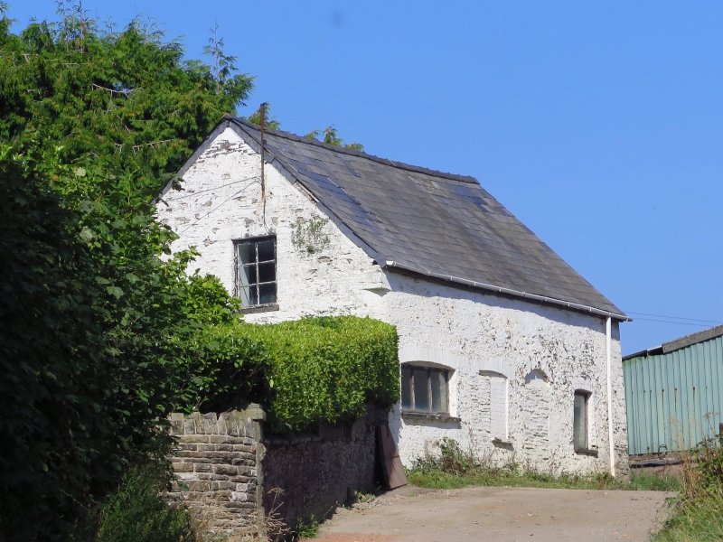
Part of the original farm complex, shown on Tithe Map before farmhouse conversion to colliery owner's residence. Probably originally a stable and the precursor of the stable of 1838 at the end of the drive; it was reputedly used later as a school.

Exterior

Small farm building of whitewashed rubble with Welsh slate roof. Main frontage faces farmyard with 2 cambered-arched side windows and two adjacent blocked doorways, one cambered-arched and one round-arched. Loft has window in gable end and cart bay beneath.

Reasons for Listing

Included as a traditional farm building associated with and for group value with Cascade House.

External Links

External links are from the relevant listing authority and, where applicable, Wikidata. Wikidata IDs may be related buildings as well as this specific building. If you want to add or update a link, you will need to do so by editing the Wikidata entry.

Recommended Books

Other nearby listed buildings

  • II Cascade House
    E of the main village development, on the N slope above Nant y Cascade, set within landscaped grounds, surrounded by farmland and reached by a drive.
  • II Stable at Cascade House drive
    Near the entrance of the drive to Cascade House
  • II Tir Pengam including attached barn and byre range to S
    On the W slope of the Rhymney Valley close to the railway and E of the village of Pen-pedair-heol, surrounded by farmland and reached by a short drive from the road.
  • II Tir-y-berth County Primary School
    Fronting the road which runs N/S along the W side of the Rhymney Valley between the railway and the river
  • II Pengam & Fleur de Lis war memorial
    Approximately 60m NE of the parish church, set back from the road and enclosed by modern railings.
  • II Horeb Baptist Church
    Located in a terrace of cottages next to Gelligaer graveyard, a very small front courtyard being formed by iron railings and gate.
  • II Church of St Catwg
    Fronting the main crossroads in the village centre, within a churchyard which backs onto the site of Gaer Fawr, a Roman Fort.

BritishListedBuildings.co.uk is an independent online resource and is not associated with any government department. All government data published here is used under licence. Please do not contact BritishListedBuildings.co.uk for any queries related to any individual listed building, planning permission related to listed buildings or the listing process itself.

British Listed Buildings is a Good Stuff website.