Approximate Location Map
Large Map »
Latitude: 51.5708 / 51°34'14"N
Longitude: -3.3266 / 3°19'35"W
OS Eastings: 308155
OS Northings: 186604
OS Grid: ST081866
Mapcode National: GBR HQ.DCXW
Mapcode Global: VH6DR.9S66
Plus Code: 9C3RHMCF+89
Entry Name: Church of St Illtyd
Listing Date: 31 October 1954
Last Amended: 19 July 2001
Grade: II
Source: Cadw
Source ID: 25541
Building Class: Religious, Ritual and Funerary
ID on this website: 300025541
Location: At corner of St Illtyd Road and Church Road
County: Rhondda Cynon Taff
Community: Llantwit Fardre (Llanilltud Faerdref)
Community: Llantwit Fardre
Locality: Upper Church Village
Built-Up Area: Church Village
Traditional County: Glamorgan
Tagged with: Church building
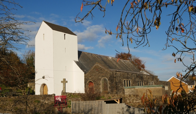
Nave and chancel said to date from around 1525; west tower dated 1636. Large extensions to S side of nave 1972-74.
Brown rubble with slate roofs; nave, lower chancel, rendered tower. Tower has saddle-back roof, and round-headed W doorway; datestone with inscription "This stee/ple was made AM/DOM 1636/ Thomas Robt/ (Builder?)".
Nave has 2 windows, camber-headed window to W, and two 2-light Gothic windows. Chancel has 2-light N window, and 2-light Gothic E window.
On S side, modern extension in matching materials runs along whole elevations of nave and chancel; pitched roof next to nave; flat roof next to chancel; square-headed mullioned windows.
Nave with segmental plaster ceiling; chancel with 2 arch-braced trusses. Stained glass in nave (NW) by Frank Roper.
Listed for surviving early fabric
External links are from the relevant listing authority and, where applicable, Wikidata. Wikidata IDs may be related buildings as well as this specific building. If you want to add or update a link, you will need to do so by editing the Wikidata entry.


Other nearby listed buildings
