History in Structure

War Memorial

A Grade II Listed Building in Dinas Powis, Vale of Glamorgan

More Photos »
Approximate Location Map
Large Map »

Coordinates

Latitude: 51.4343 / 51°26'3"N

Longitude: -3.2196 / 3°13'10"W

OS Eastings: 315318

OS Northings: 171293

OS Grid: ST153712

Mapcode National: GBR HW.NWBX

Mapcode Global: VH6FL.46ST

Plus Code: 9C3RCQMJ+P5

Entry Name: War Memorial

Listing Date: 3 May 2002

Last Amended: 3 May 2002

Grade: II

Source: Cadw

Source ID: 26506

Building Class: Commemorative

ID on this website: 300026506

Location: In the middle of the triangular green at the centre of the village on paving enclosed by chain fencing hung from stone piers.

County: Vale of Glamorgan

Town: Cardiff

Community: Dinas Powys

Community: Dinas Powys

Built-Up Area: Dinas Powis

Traditional County: Glamorgan

Tagged with: War memorial

Find accommodation in
Dinas Powis

History

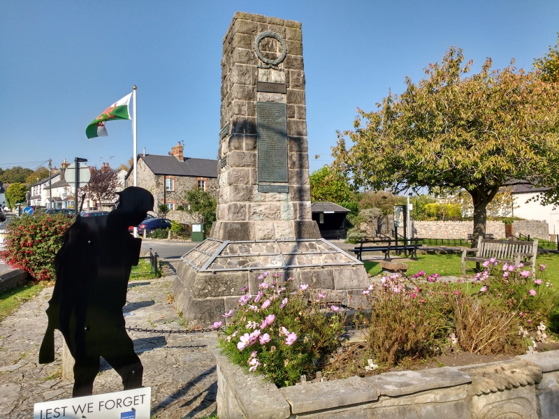
Commemorating the dead of the First and (later) Second World Wars. First dedicated in 1935 following controversy over the form the memorial should take, in particular whether a hospital should be built. Original design was for a cross. Earlier photograph confirms the 'crazy paving' surface to the plinth to be a later insertion; the original design provided the traditional step/ledge for wreaths. Other nearby features on the Green are a stone trough incorporating a stone engraved with a lion's head and a fountain erected to commemorate reign of Edward VII.

Exterior

War Memorial. Plain tapered pier of coursed rock-faced stone on a wide plinth with an upper surface of random-set stone. Cast metal plaques record the names of the dead, surmounted by a metal wreath on the main S elevation.

Reasons for Listing

Included as a village war memorial in prominent village centre position. Group value with the Old Court.

External Links

External links are from the relevant listing authority and, where applicable, Wikidata. Wikidata IDs may be related buildings as well as this specific building. If you want to add or update a link, you will need to do so by editing the Wikidata entry.

Recommended Books

Other nearby listed buildings

  • II Old Court
    Fronting the W side of the triangular green in the village centre, and at the end of the row attached to The Star Inn.
  • II Dinas Powys Parish Hall
    Just to W and on rising ground above the village centre, on a railed and walled terrace of random stone reached by steps.
  • II Church of St Peter
    On low-lying ground by the Cadoxton River a short distance N of the village centre.
  • II The Mount
    Facing the Common on ground rising from and SW of the village centre. Set back from the road in a walled garden with entrance comprising tall rendered piers and tall decorative wrought iron gates.
  • II Remains of Dinas Powis Castle
    On a wooded spur in Castle Wood, immediately above the C20 development of Lettons Way and reached by footpath from there.
  • II Lon Twyn
    On rising ground NW of the village centre, set within terraced gardens with views S over the Bristol Channel.
  • II 1-6, Little Orchard
    Little Orchard is a small cul-de-sac opening off the original line of Murch Road on the east side of Dinas Powys. The 6 houses are sited above the access road on its east and south sides.
  • II Garn-hill and attached garden terrace
    On a south facing slope NE of the hamlet of St Andrews Major, reached by a long drive from the hamlet and set in terraced gardens.

BritishListedBuildings.co.uk is an independent online resource and is not associated with any government department. All government data published here is used under licence. Please do not contact BritishListedBuildings.co.uk for any queries related to any individual listed building, planning permission related to listed buildings or the listing process itself.

British Listed Buildings is a Good Stuff website.