Latitude: 51.6267 / 51°37'36"N
Longitude: -3.3305 / 3°19'49"W
OS Eastings: 308000
OS Northings: 192826
OS Grid: ST080928
Mapcode National: GBR HQ.8QZG
Mapcode Global: VH6DK.7C5T
Plus Code: 9C3RJMG9+MR
Entry Name: Taff Vale Railway bridge over Cwm Clydach
Listing Date: 12 December 2002
Last Amended: 12 December 2002
Grade: II
Source: Cadw
Source ID: 80764
ID on this website: 300080764
Location: On the very S boundary of the community, at the junction of Cwm Clydach with Taff Vale.
County: Rhondda Cynon Taff
Community: Abercynon
Community: Abercynon
Locality: Glyncoch
Traditional County: Glamorgan
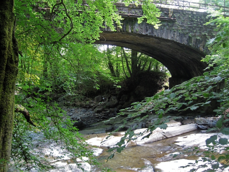
The Taff Vale Railway was the original and leading independent railway of the region in mid C19, opening up access between the iron and coal-producing Valleys and Cardiff, with its main outlet on Bute West Dock. The congestion on the Glamorganshire Canal of the 1830s was the stimulus and its promoters were ironmasters Sir John Josiah Guest head of Dowlais Ironworks and Walter Coffin who developed coal-mining in the Rhondda. It was engineered by Isambard Kingdom Brunel and received Royal Assent in 1836. Cardiff to Navigation House at Abercynon section was opened in 1840, onward to Merthyr in 1841. At first a single track, the doubling to Navigation House was achieved in 1847. The original line is 24.5 miles (39.4 km) long; it subsequently developed a number of branches. The route in this area follows the left bank of the River Taff, here crossing Cwm Clydach. The bridge has been reinforced in 1980s and 90s with iron ties on patras plates.
A wide triple-arched slightly skewed railway bridge crossing at S the main road which runs N/S along the W bank of the River Taff, at centre Nant Clydach which flows into the Taff a short distance to E, and at N a lane along the N side of Nant Clydach. Built of coursed rock-faced stone with very deep rock-faced voussoirs, some with diamond-shaped ends, each adjoining a separate stone course; the voussoirs are tooled as quoins on the return inside the arch. Deep and wide plinth. Uneven arches, the river-arch the widest. Some curved rubble abutments to banks. Low parapet of tooled stone with iron railings and 3 rows of wire.
Under all three arches there is a noticeable break between the E and W sides, no doubt representing the track-doubling, though there is no change in masonry style.
Listed as a fine tri-partite bridge of the historically pioneering Taff Vale Railway. Group value with nearby road bridge.
External links are from the relevant listing authority and, where applicable, Wikidata. Wikidata IDs may be related buildings as well as this specific building. If you want to add or update a link, you will need to do so by editing the Wikidata entry.


Other nearby listed buildings