History in Structure

Milestone to W of Tregeiriog

A Grade II Listed Building in Ceiriog Ucha, Wrexham

More Photos »
Approximate Location Map
Large Map »

Coordinates

Latitude: 52.894 / 52°53'38"N

Longitude: -3.2318 / 3°13'54"W

OS Eastings: 317227

OS Northings: 333661

OS Grid: SJ172336

Mapcode National: GBR 6W.PMH2

Mapcode Global: WH78H.BJ97

Plus Code: 9C4RVQV9+J7

Entry Name: Milestone to W of Tregeiriog

Listing Date: 23 May 2003

Last Amended: 23 May 2003

Grade: II

Source: Cadw

Source ID: 81167

Building Class: Transport

ID on this website: 300081167

Location: Located on the N side of the road on a grass verge, the bank rising steeply behind.

County: Wrexham

Community: Ceiriog Ucha

Community: Ceiriog Ucha

Locality: Tregeiriog

Traditional County: Denbighshire

Tagged with: Milestone

Find accommodation in
Llanarmon Dyffryn-Ceiriog

History

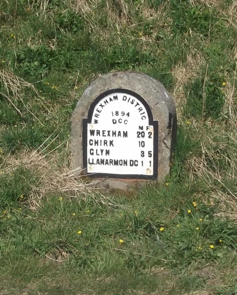
One of a series of milestones along this road erected by Denbighshire County Council in 1894, when they took control of the county''''s highways.

Exterior

Square-section milestone with arched top. Attached to the front is a cast iron plate with arched head, raised margin and letters in relief. It reads ''''Wrexham District / 1894 / DCC'''' under the arch. Beneath are distances in miles and furlongs: ''''Wrexham 20.2 / Chirk 10 / Glyn 3.5 / Llanarmon DC 1.1''''.

Reasons for Listing

Listed for its historic interest as a well-preserved County Council milestone, one of the few to survive on this stretch of road.

External Links

External links are from the relevant listing authority and, where applicable, Wikidata. Wikidata IDs may be related buildings as well as this specific building. If you want to add or update a link, you will need to do so by editing the Wikidata entry.

Recommended Books

Other nearby listed buildings

  • II Pont y Felin
    Located 300m S of the main crossroads in Tregeiriog, and carrying the lane to Rhiwlas over the River Ceiriog.
  • II Hafod Adams
    Located on the W side of a lane which runs N from the B4500, between Tregeiriog and Llanarmon Dyffryn Ceiriog. The entrance faces W, away from the road.
  • II Secondary Dwelling at Hafod Adams
    Located immediately to the W of Harod Adams Farmhouse. The W elevation overlooks the Nant Caledwynt, whilst the E side faces the farmhouse.
  • II Cart-shed and granary to W of Ty-du Farmhouse
    Located immediately to the W of, and aligned with the farmhouse.
  • II Ty-du
    Set down from the B4500 and reached by a short track, approx 0.7km E of Tregeiriog. Flanked by late C19 outbuildings in the same style.
  • II Service Building to E of Ty-du Farmhouse
    Located immediately to the E of, and aligned with the farmhouse.
  • II Cow-house with adjoining cart-shed S of Fodwen
    Located directly opposite and to the S of Fodwen Farmhouse. The front faces N.
  • II Fodwen
    Located in an upland position on a track which runs NW off a lane which leads N from the B4500 at Pont Caledwynt.

BritishListedBuildings.co.uk is an independent online resource and is not associated with any government department. All government data published here is used under licence. Please do not contact BritishListedBuildings.co.uk for any queries related to any individual listed building, planning permission related to listed buildings or the listing process itself.

British Listed Buildings is a Good Stuff website.